North Lakes


| North Lakes Osceola, WI to Denver, IN 3 Map Set (1159.5 mi.) |
GPX Data | Overview
North Lakes Overview Image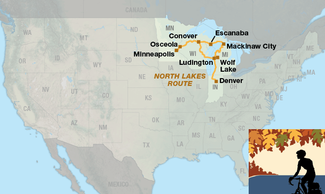
|
|---|---|
| 1. Minneapolis, MN to Escanaba, MI (439.5 mi.) | Detail
North Lakes Section 1 Detail Image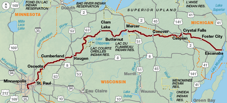
|
| 2. Escanaba, MI to Mackinaw City, MI (151 mi.) | Detail
North Lakes Section 2 Detail Image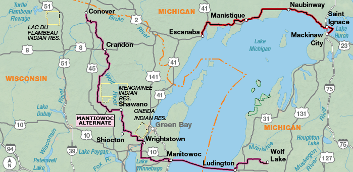
|
| 3. Mackinaw City, MI to Denver, IN (569 mi.) | Detail
North Lakes Section 3 Detail Image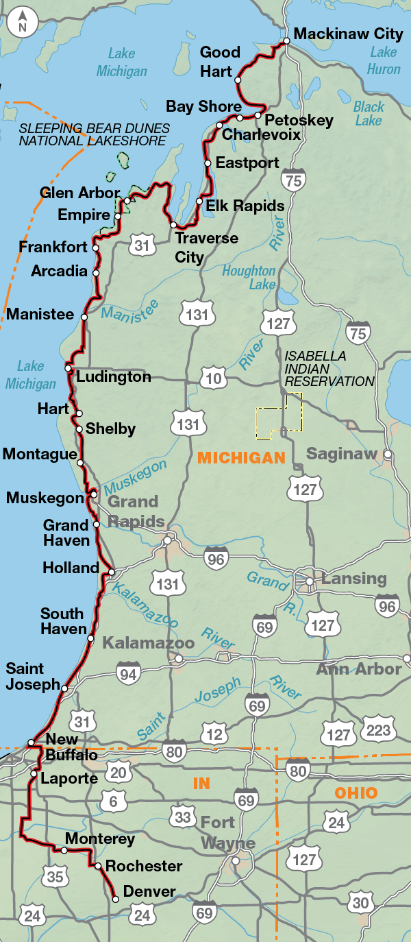
|
Experience the north woods and lakes.
The North Lakes Bicycle Route is very pleasant to ride if you like biking through hardwood forests, lakes and farmlands. Its beauty is subtle rather than dramatic. It's a route in which high-mileage days are possible, if you are so inclined, because it is not particularly difficult. If you are doing the Northern Tier, you can use sections one, two and three along with the Lake Erie Connector to stay north instead of dropping south and going through Iowa, Illinois, Indiana, and Ohio. The Manitowoc Alternate uses a ferry across Lake Michigan and shortens the route by about 200 miles. The ferry is pricey, so call for more information before you decide to ride the alternate.
The route begins just outside the Minneapolis-St. Paul International Airport. It uses bike paths and city streets and connects to the Gateway State Trail, a beautiful path that leads you out of the Twin Cities metropolitan area. You'll cross the St. Croix River into Osceola, Wisconsin. The route goes through dairy farmland and makes a gradual transition to the hardwood forests and lakes in the northern part of the state.
After Wisconsin, you'll bike through the farmlands of the Upper Peninsula in Michigan and ride alongside Lake Michigan. At St. Ignace, a ferry takes you across the Mackinac Straits into Lower Michigan. But be sure to take some time for a visit on Mackinac Island, and do the short eight-mile loop around the island. You'll share the road with only horses and buggies, pedestrians, and other bicyclists as motorized vehicles are banned from the island. The area between Mackinaw City and Traverse City, at the northern tip of Lower Michigan, is a favorite spot for vacationing tourists.
South of Harbor Springs, the route is concurrent with U.S. Bicycle Route (USBR) 35, except where noted. Be aware that signs can be damaged, stolen, or otherwise missing so you can never rely totally on following signs. For more information and other maps of the region see www.michigan.gov/mdot-biking.
From Suttons Bay, the route crosses the Leelanau Peninsula to the Sleeping Bear Dunes National Lakeshore. From here going south, you’ll follow rural roads and state highways through small vacation towns along the Lake Michigan shore. Please be cautious of tourist traffic during summer months.
At New Buffalo, the route leaves Lake Michigan on rural roads across Indiana farmland to Denver, finishing on the Nickel Plate Trail. From here, you can rejoin the Northern Tier heading east or west.
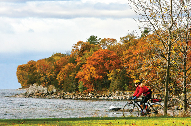
Photo by Dennis Coello
The North Lakes Route is generally rolling and one of Adventure Cycling's easier routes to ride. There are no dramatic climbs over mountain passes. This is not to say that there aren't any short, steep climbs, but difficult climbing is not the general terrain of this route.
| North Lakes - Main Route | ||||
|---|---|---|---|---|
| Section | Distance | Elevation | Total Climb | Avg. Climb/mile |
| Total | 1159.5 miles | Minimum: 580 ft. Maximum: 1,860 ft. |
31,245 ft. southeast bound 31,120 ft. northwest bound |
27 ft. per mi. southeast bound 27 ft. per mi. northwest bound |
| 1 | 439.5 miles | Minimum: 600 ft. Maximum: 1,845 ft. |
16,130 ft. southeast bound 16,330 ft. northwest bound |
37 ft. per mi. southeast bound 37 ft. per mi. northwest bound |
| 2 | 151.0 miles | Minimum: 580 ft. Maximum: 800 ft. |
2,410 ft. southeast bound 2,420 ft. northwest bound |
16 ft. per mi. southeast bound 16 ft. per mi. northwest bound |
| 3 | 569.0 miles | Minimum: 580 ft. Maximum: 950 ft. |
14,550 ft. southeast bound 14,350 ft. northwest bound |
26 ft. per mi. southeast bound 25 ft. per mi. northwest bound |
| North Lakes Alternates | ||||
|---|---|---|---|---|
| Name | Section | Distance | Total Climb | Avg. Climb/mi |
| Manitowoc Alternate | 2 | 296.5 miles | 8,035 ft. southeast bound 8,755 ft. northwest bound |
27 ft. per mi. southeast bound 30 ft. per mi. northwest bound |
The North Lakes Bicycle Route can be ridden from late spring to mid-fall (typically May to September). Due to changing local conditions, it is difficult to predict any major wind patterns. Summer temperatures can be cool.
Services are generally plentiful. There are some especially nice campgrounds and resorts in northern Wisconsin where people like to spend their vacations "at the lake." Some cyclists may want to do this route during the colors of autumn. If you do, call ahead to verify campgrounds because many close after Labor Day. If staying indoors, make advance reservations.
Some campgrounds will charge a cyclist traveling by himself less if they have hiker/biker sites, but often they will charge the price of a regular tent or RV site, and that can easily be $10-$30/night. The maps list churches that have opened their doors to cyclists, but they aren't all that closely spaced. If you're friendly and ask around, you can often get yourself invited to camp in a yard. Our routes sometimes go through national forests (moreso in the west) and you are allowed to camp anywhere on national forest land as long as you "pack it in, pack it out." Many city parks are free to camp in.
You may also wish to sign up with Warmshowers, a reciprocal hospitality site for bicycle travelers, for other overnight options.
Route Highlights
- Interstate State Park, Section 1
- Minneapolis and St. Paul, Section 1
- Michigan's Upper Peninsula, Section 2
- Mackinac Island, Section 2
- Tunnel of Tress, Section 3
- Sleeping Bear Dunes, Section 3
- LaPorte, Indiana, Section 3
More Route Resources
- U.S. Bicycle Route System
- No-Turn-Away Bike Camping Policies (Michigan, Minnesota, Wisconsin)
- Minnesota DOT bike maps
- Minneapolis and St. Paul Twin Cities bike map (Minnesota)
- Access to Minneapolis/St. Paul International Airport (Minnesota)
- Minneapolis/St. Paul light rail (Minnesota)
- Gateway State Trail (Minnesota)
- Wisconsin DOT bike maps
- St. Croix Falls trail map (Wisconsin)
- Gandy Dancer Trail (Wisconsin)
- Heart of Vilas County & Crystal Lake Bike Trails (Wisconsin)
- Wolf River State Trail (Wisconsin)
- Mountain-Bay State Recreation Trail (Wisconsin)
- SS Badger Ferry across Lake Michigan
- U.S. Bicycle Route 20 & 35 (Michigan)
- Michigan DOT bike maps
- Mackinac Bridge crossing (Michigan)
- Shepler's Mackinac Island Ferry (Michigan)
- Star Line Ferry Mackinac Island Ferry (Michigan)
- Little Traverse Wheelway (Michigan)
- TART Trail (Michigan)
- Hart Montague Trail (Michigan)
- Muskegon Lakeshore Trail (Michigan)
- U.S Bicycle Route 35 (Indiana)
- North Judson Erie Trail (Indiana)
- Nickel Plate Trail (Indiana)
- Connect and share photos with other riders on Instagram: #acaNoLakes
RIDING CONDITIONS
Beginning just outside the Minneapolis/St. Paul International Airport, the route uses several bike paths in Minneapolis through state and city parks situated along the Mississippi River. Ride slowly and be on the lookout for pedestrians, runners, and skaters. The route is also part of U.S. Bicycle Route (USBR) 45A and is sometimes signed as the Mississippi River Trail. For more information and maps see: advcy.link/mnusbr45. In St. Paul you will get onto the Gateway State Trail, a multi-use recreational trail. It is built on the former Soo Line Railway grade, and passes through urban areas and parks. As you head away from the cities, it traverses wetlands, fields, and wooded countryside. More information at advcy.link/mngatewaytrl.
Traffic increases on SR 95 along the St. Croix River. This road is narrow and has heavy recreational traffic in the summer. Ride carefully.
In Osceola, Wisconsin, still following the St. Croix River, the route is mostly flat as it makes a gradual transition from dairy farms to northern lakes, pine and birch forests. A trail map for St. Croix Falls is available at: advcy.link/stcroixfallsmap. Out of St. Croix Falls, the route uses 4.5 miles of the Gandy Dancer Trail and you will need to purchase a State Trail Pass. The surface of this interstate trail is crushed limestone. For more information on this trail see: advcy.link/gandydtrl.
The county roads through the northern Wisconsin lakes are narrow, hilly and rough in some places. Traffic is light except during mid-late summer harvest season when truck traffic picks up.
Outside of Haugen you may be tempted to take the nearby unpaved Tuscobia Park Falls and Wild Rivers State Trails. This is not advised as state officials say they are suited only for unloaded mountain bikes.
The rolling hills continue in the western Upper Peninsula of Michigan on narrow county roads. The route uses two paved trails from just north of Manitowish Waters through Boulder Junction. A trail map of the area can be found at: advcy.link/hovtrl. Traffic picks up a bit around Crystal Falls, but SR 69 from Crystal Falls to Escanaba is a smooth, wide, two lane road with few services and fewer cars, but occasional logging trucks. The route intersects with USBR 10 in Escanaba. For more information and maps see: advcy.link/miusbr10.
NOTE: If cycling this route to enjoy the fall colors, we recommend you call ahead to campgrounds to verify that they are open. Many close after Labor Day.
CLIMATE
Northern Wisconsin and the Upper Peninsula (UP) of Michigan both have a humid continental climate with cool summers. The climate is characterized by extremes of heat and cold caused by cyclonic storms that move across the region from west to east. The eastern edge of Wisconsin and the southern part of the UP receive the benefit of the moderating influence of Lake Michigan, which causes the summers to be somewhat cooler and the winters to be somewhat warmer.
Precipitation levels vary throughout the region. Areas of the Upper Peninsula have a yearly frost-free season of 60 to 120 days, and annual precipitation ranges from about 16 to 32 inches. Wisconsin precipitations are more uniformly distributed, averaging around 33 inches throughout the state. Both the Upper Peninsula and Wisconsin receive considerable snowfall each year, averaging about 55 inches per year.
Updated: Sep 24, 2018RIDING CONDITIONS
From Escanaba to St. Ignace the route stays mostly on U.S. 2. This highway is very busy with both recreational and commercial traffic, but has wide paved shoulders. In general, when U.S. 2 is directly on the Lake Michigan shore or well inland it is flat, but in between there are numerous climbs over coastal bluffs which provide spectacular views of the lake. Be prepared for constant wind off the lake, frequently from the southwest.
On SR 35 north of Wells, the area around the Escanaba River bridge is dangerous, with traffic entering and leaving the highway in all directions.
County and state roads between Cooks and Manistique are a welcome respite from the noise and wind of U.S. 2, but carry frequent recreational traffic to the State Parks in the area.
For approximately three miles west of St. Ignace, U.S. 2 widens to 5 lanes and loses its shoulder. Ride carefully. An alternative is the paved trail on either side of U.S. 2. Many businesses are located along this stretch; watch for cars entering and exiting across the trail.
The Mackinac Bridge between St. Ignace and Mackinaw City, which connects Michigan’s Upper and Lower Peninsulas, is part of I-75, and bicycles are prohibited. The Mackinac Bridge Authority offers rides across the bridge for $5/bicycle. For groups of three or more, you need to call in advance: 906-643-7600. In St. Ignace, ride to the administration building on the east side of the toll plaza. Go to the service window and ask for assistance In Mackinaw City, just after the last exit (#339) before the bridge, stop at the building beside the highway fence and use the phone at the south end of the bridge. Bridge personnel will pick you up at that spot and leave you at the administration building on the north side.
U.S. Bicycle Route (USBR) 45 has been designated in Michigan. Most of our route runs concurrent with it. For more information and maps see advcy.link/miusbr10.
Adventure Cycling recommends riding the ferry to Mackinac Island to cross the Straits of Mackinac. No motorized vehicles are permitted on the island, which is 80% state park, and 20% privately owned. Passenger ferries are run by three companies that have docks in both St. Ignace and Mackinaw City, and prices are the same for all three lines. No advance reservations are needed, and boats run frequently in the summer. To take advantage of the ferries, plan on staying overnight in both Mackinaw City and St. Ignace and spending the whole day on the Island.
The Manitowoc Alternate leaves the main route in Conover, Wisconsin, heads southeast to Manitowoc, crosses Lake Michigan, and rejoins the route near Wolf River, Michigan. It is 209 miles shorter than the main route. It is concurrent with signed U.S. Bicycle Routes (USBR) 20 and 35 in Michigan. Be aware that signs can be damaged, stolen, or otherwise missing so you can never rely totally on following signs. For more information and maps see advcy.link/miusbr20 and advcy.link/miusbr35,
The forests, lakes, and rolling hills of northern Wisconsin add to the beauty of cycling in the area, but they also tend to increase the number of curves on the roads and decrease motorists’ visibility. Be particularly vigilant and use defensive cycling techniques in the Nicolet National Forest.
Between Crandon and Lily you will cross the unpaved Wolf River State Trail several times.
From Shawano southward, the farm country of central Wisconsin features excellent roads with very little traffic. You will encounter farm equipment and trucks, so try to stay as far as possible to the right to allow them room to pass. The “Tri-Cities” of Neehnah, Menasha, and Appleton make for fairly heavy traffic around Lake Winnebago. This is also a popular summer destination, so be sure to make overnight reservations early in the day.
Rolling farmland characterizes the route from Wrightstown to Manitowoc. The traffic in Manitowoc will seem heavy after the rural roads you’ve been on. In Manitowoc you will take the ferry to Ludington, Michigan.
The ferry that crosses Lake Michigan, while pricey, will provide an exciting diversion from pedaling. It is open from mid-May to October. If you “check” your bike and panniers as luggage, be sure to keep some warm clothing with you for the trip across the lake. A camera is also recommended, since you’ll have plenty of photo opportunities during the cruise. Call the Lake Michigan Carferry Service for information about cost and schedules at 800-841-4243 or check their website: www.ssbadger.com. Do this before you make the decision to use the Alternate.
CLIMATE
Despite Michigan and Wisconsin’s mid-continental location, the weather is largely influenced by the presence of Lake Michigan, resulting in a more moderate climate than other midwest states. The localized wind patterns from Lake Michigan are based on “lake breezes” during the day and their converse, “land breezes”, in the evening. Lake breezes originate on the water while land breezes, the shore. They are generally light and only extend inland a few miles. Precipitation in the summer months tends to fall in the form of showers or thunderstorms and humidity can be high throughout the year.
Updated: Sep 24, 2018RIDING CONDITIONS
From Mackinaw City to Cross Village, the route primarily follows two-lane county roads through farms. There are several public beach access points on Lakeview Dr. and Wilderness Park Dr. in Wilderness State Park. From the campground at Wilderness State Park, you can see a glorious sunset over Lake Michigan with the distant view of the Mackinaw Bridge. In Cross Village, sample authentic Polish food at the historic Legs Inn. The Tunnel of Trees Scenic Route from Cross Village to Harbor Springs is a narrow road, mostly without a centerline, but traffic is light and slow moving. Harbor Springs is a congested, busy tourist town.
South of Harbor Springs, the route is concurrent with U.S. Bicycle Route (USBR) 35, except where noted. As of this printing, USBR 35 is in the process of being signed. Be aware that signs can be damaged, stolen, or otherwise missing so you can never rely totally on following signs. For more information and other maps of the region see www.michigan.gov/mdot-biking.
From Harbor Springs to Charlevoix, the route follows the Little Traverse Wheelway (LTW) bike path. In Petoskey, LTW is on the “Pink Sidewalk” for about 1 mile to avoid very busy US 31. Between Charlevoix and Elk Rapids, the route diverges from USBR 35 to follow rural roads and avoid US 31 as much as possible. From just south of Acme through Traverse City and on to Suttons Bay is the TART Trail, an off-road path that leads through the State Park and downtown Traverse City. Do not attempt to ride on US 31, which is narrow and dangerous, and has high levels of traffic.
From Suttons Bay, the route crosses the Leelanau Peninsula to the Sleeping Bear Dunes National Lakeshore. From here to Pentwater, you’ll follow rural roads and state highways through small vacation towns along the Lake Michigan shore. Please be cautious of tourist traffic during summer months.
At Pentwater, the route leaves the lakeshore following rural roads to Hart and picks up the Hart-Montague Trail that carries you to the south end of Whitehall. The route follows rural/residential roads to North Muskegon where you find a busy commercial area on Ruddimann Dr. and Lake St. The Muskegon Lakeshore Trail follows the waterfront and avoids most city traffic through Muskegon. Between Ferrysburg and Grand Haven, you’ll ride through Ferry Park and follow bike paths across the Grand River to avoid dangerous bridges on US 31.
South of Grand Haven, a bike path parallels Lakeshore Dr. and Butternut Dr. into Holland. River Ave., downtown Holland, and Shore Dr are best avoided during commuter periods. The Blue Star Highway, connecting the upscale lakefront towns of Saugatuck, South Haven, and Saint Joseph, has good shoulders and moderate traffic since I-196 carries the bulk of the traffic. South of Saint Joseph, the Red Arrow Highway is primarily a four-lane highway with no shoulders, though the route avoids this where possible using Lakeshore Dr.
At New Buffalo, the route leaves Lake Michigan on rural roads across Indiana farmland to La Porte. The route follows the residential streets through La Porte before heading out on rural farm roads to Rochester and you’ll finish this section on the Nickel Plate Trail to Denver.
Entering Indiana, you will be in Central Time Zone for about 40 miles before returning to the Eastern Time Zone at the La Porte-Starke County line south of North Judson.
NOTE: If cycling this route to enjoy the fall colors, we recommend you call ahead to campgrounds to verify that they are open. Many close after Labor Day.
CLIMATE
During summer months winds are predominantly from the southwest. When prevailing winds are generally light, Lake Michigan’s shore area frequently develops a localized wind pattern which may extend inland for only a few miles. Summer precipitation falls primarily in the form of showers or thunderstorms.
Updated: Dec 21, 2017-
GPX Data |
Overview
North Lakes Overview Image

- 1. Minneapolis, MN to Escanaba, MI (439.5 mi.)
-
Detail
| Map Updates and Corrections
North Lakes Section 1 Detail Image

- 2. Escanaba, MI to Mackinaw City, MI (151 mi.)
-
Detail
| Map Updates and Corrections
North Lakes Section 2 Detail Image

- 3. Mackinaw City, MI to Denver, IN (569 mi.)
-
Detail
| Map Updates and Corrections
North Lakes Section 3 Detail Image

Experience the north woods and lakes.
The North Lakes Bicycle Route is very pleasant to ride if you like biking through hardwood forests, lakes and farmlands. Its beauty is subtle rather than dramatic. It's a route in which high-mileage days are possible, if you are so inclined, because it is not particularly difficult. If you are doing the Northern Tier, you can use sections one, two and three along with the Lake Erie Connector to stay north instead of dropping south and going through Iowa, Illinois, Indiana, and Ohio. The Manitowoc Alternate uses a ferry across Lake Michigan and shortens the route by about 200 miles. The ferry is pricey, so call for more information before you decide to ride the alternate.
The route begins just outside the Minneapolis-St. Paul International Airport. It uses bike paths and city streets and connects to the Gateway State Trail, a beautiful path that leads you out of the Twin Cities metropolitan area. You'll cross the St. Croix River into Osceola, Wisconsin. The route goes through dairy farmland and makes a gradual transition to the hardwood forests and lakes in the northern part of the state.
After Wisconsin, you'll bike through the farmlands of the Upper Peninsula in Michigan and ride alongside Lake Michigan. At St. Ignace, a ferry takes you across the Mackinac Straits into Lower Michigan. But be sure to take some time for a visit on Mackinac Island, and do the short eight-mile loop around the island. You'll share the road with only horses and buggies, pedestrians, and other bicyclists as motorized vehicles are banned from the island. The area between Mackinaw City and Traverse City, at the northern tip of Lower Michigan, is a favorite spot for vacationing tourists.
South of Harbor Springs, the route is concurrent with U.S. Bicycle Route (USBR) 35, except where noted. Be aware that signs can be damaged, stolen, or otherwise missing so you can never rely totally on following signs. For more information and other maps of the region see www.michigan.gov/mdot-biking.
From Suttons Bay, the route crosses the Leelanau Peninsula to the Sleeping Bear Dunes National Lakeshore. From here going south, you’ll follow rural roads and state highways through small vacation towns along the Lake Michigan shore. Please be cautious of tourist traffic during summer months.
At New Buffalo, the route leaves Lake Michigan on rural roads across Indiana farmland to Denver, finishing on the Nickel Plate Trail. From here, you can rejoin the Northern Tier heading east or west.
Photo by Dennis Coello
RIDING CONDITIONS
Beginning just outside the Minneapolis/St. Paul International Airport, the route uses several bike paths in Minneapolis through state and city parks situated along the Mississippi River. Ride slowly and be on the lookout for pedestrians, runners, and skaters. The route is also part of U.S. Bicycle Route (USBR) 45A and is sometimes signed as the Mississippi River Trail. For more information and maps see: advcy.link/mnusbr45. In St. Paul you will get onto the Gateway State Trail, a multi-use recreational trail. It is built on the former Soo Line Railway grade, and passes through urban areas and parks. As you head away from the cities, it traverses wetlands, fields, and wooded countryside. More information at advcy.link/mngatewaytrl.
Traffic increases on SR 95 along the St. Croix River. This road is narrow and has heavy recreational traffic in the summer. Ride carefully.
In Osceola, Wisconsin, still following the St. Croix River, the route is mostly flat as it makes a gradual transition from dairy farms to northern lakes, pine and birch forests. A trail map for St. Croix Falls is available at: advcy.link/stcroixfallsmap. Out of St. Croix Falls, the route uses 4.5 miles of the Gandy Dancer Trail and you will need to purchase a State Trail Pass. The surface of this interstate trail is crushed limestone. For more information on this trail see: advcy.link/gandydtrl.
The county roads through the northern Wisconsin lakes are narrow, hilly and rough in some places. Traffic is light except during mid-late summer harvest season when truck traffic picks up.
Outside of Haugen you may be tempted to take the nearby unpaved Tuscobia Park Falls and Wild Rivers State Trails. This is not advised as state officials say they are suited only for unloaded mountain bikes.
The rolling hills continue in the western Upper Peninsula of Michigan on narrow county roads. The route uses two paved trails from just north of Manitowish Waters through Boulder Junction. A trail map of the area can be found at: advcy.link/hovtrl. Traffic picks up a bit around Crystal Falls, but SR 69 from Crystal Falls to Escanaba is a smooth, wide, two lane road with few services and fewer cars, but occasional logging trucks. The route intersects with USBR 10 in Escanaba. For more information and maps see: advcy.link/miusbr10.
NOTE: If cycling this route to enjoy the fall colors, we recommend you call ahead to campgrounds to verify that they are open. Many close after Labor Day.
CLIMATE
Northern Wisconsin and the Upper Peninsula (UP) of Michigan both have a humid continental climate with cool summers. The climate is characterized by extremes of heat and cold caused by cyclonic storms that move across the region from west to east. The eastern edge of Wisconsin and the southern part of the UP receive the benefit of the moderating influence of Lake Michigan, which causes the summers to be somewhat cooler and the winters to be somewhat warmer.
Precipitation levels vary throughout the region. Areas of the Upper Peninsula have a yearly frost-free season of 60 to 120 days, and annual precipitation ranges from about 16 to 32 inches. Wisconsin precipitations are more uniformly distributed, averaging around 33 inches throughout the state. Both the Upper Peninsula and Wisconsin receive considerable snowfall each year, averaging about 55 inches per year.
Updated: Sep 24, 2018RIDING CONDITIONS
From Escanaba to St. Ignace the route stays mostly on U.S. 2. This highway is very busy with both recreational and commercial traffic, but has wide paved shoulders. In general, when U.S. 2 is directly on the Lake Michigan shore or well inland it is flat, but in between there are numerous climbs over coastal bluffs which provide spectacular views of the lake. Be prepared for constant wind off the lake, frequently from the southwest.
On SR 35 north of Wells, the area around the Escanaba River bridge is dangerous, with traffic entering and leaving the highway in all directions.
County and state roads between Cooks and Manistique are a welcome respite from the noise and wind of U.S. 2, but carry frequent recreational traffic to the State Parks in the area.
For approximately three miles west of St. Ignace, U.S. 2 widens to 5 lanes and loses its shoulder. Ride carefully. An alternative is the paved trail on either side of U.S. 2. Many businesses are located along this stretch; watch for cars entering and exiting across the trail.
The Mackinac Bridge between St. Ignace and Mackinaw City, which connects Michigan’s Upper and Lower Peninsulas, is part of I-75, and bicycles are prohibited. The Mackinac Bridge Authority offers rides across the bridge for $5/bicycle. For groups of three or more, you need to call in advance: 906-643-7600. In St. Ignace, ride to the administration building on the east side of the toll plaza. Go to the service window and ask for assistance In Mackinaw City, just after the last exit (#339) before the bridge, stop at the building beside the highway fence and use the phone at the south end of the bridge. Bridge personnel will pick you up at that spot and leave you at the administration building on the north side.
U.S. Bicycle Route (USBR) 45 has been designated in Michigan. Most of our route runs concurrent with it. For more information and maps see advcy.link/miusbr10.
Adventure Cycling recommends riding the ferry to Mackinac Island to cross the Straits of Mackinac. No motorized vehicles are permitted on the island, which is 80% state park, and 20% privately owned. Passenger ferries are run by three companies that have docks in both St. Ignace and Mackinaw City, and prices are the same for all three lines. No advance reservations are needed, and boats run frequently in the summer. To take advantage of the ferries, plan on staying overnight in both Mackinaw City and St. Ignace and spending the whole day on the Island.
The Manitowoc Alternate leaves the main route in Conover, Wisconsin, heads southeast to Manitowoc, crosses Lake Michigan, and rejoins the route near Wolf River, Michigan. It is 209 miles shorter than the main route. It is concurrent with signed U.S. Bicycle Routes (USBR) 20 and 35 in Michigan. Be aware that signs can be damaged, stolen, or otherwise missing so you can never rely totally on following signs. For more information and maps see advcy.link/miusbr20 and advcy.link/miusbr35,
The forests, lakes, and rolling hills of northern Wisconsin add to the beauty of cycling in the area, but they also tend to increase the number of curves on the roads and decrease motorists’ visibility. Be particularly vigilant and use defensive cycling techniques in the Nicolet National Forest.
Between Crandon and Lily you will cross the unpaved Wolf River State Trail several times.
From Shawano southward, the farm country of central Wisconsin features excellent roads with very little traffic. You will encounter farm equipment and trucks, so try to stay as far as possible to the right to allow them room to pass. The “Tri-Cities” of Neehnah, Menasha, and Appleton make for fairly heavy traffic around Lake Winnebago. This is also a popular summer destination, so be sure to make overnight reservations early in the day.
Rolling farmland characterizes the route from Wrightstown to Manitowoc. The traffic in Manitowoc will seem heavy after the rural roads you’ve been on. In Manitowoc you will take the ferry to Ludington, Michigan.
The ferry that crosses Lake Michigan, while pricey, will provide an exciting diversion from pedaling. It is open from mid-May to October. If you “check” your bike and panniers as luggage, be sure to keep some warm clothing with you for the trip across the lake. A camera is also recommended, since you’ll have plenty of photo opportunities during the cruise. Call the Lake Michigan Carferry Service for information about cost and schedules at 800-841-4243 or check their website: www.ssbadger.com. Do this before you make the decision to use the Alternate.
CLIMATE
Despite Michigan and Wisconsin’s mid-continental location, the weather is largely influenced by the presence of Lake Michigan, resulting in a more moderate climate than other midwest states. The localized wind patterns from Lake Michigan are based on “lake breezes” during the day and their converse, “land breezes”, in the evening. Lake breezes originate on the water while land breezes, the shore. They are generally light and only extend inland a few miles. Precipitation in the summer months tends to fall in the form of showers or thunderstorms and humidity can be high throughout the year.
Updated: Sep 24, 2018RIDING CONDITIONS
From Mackinaw City to Cross Village, the route primarily follows two-lane county roads through farms. There are several public beach access points on Lakeview Dr. and Wilderness Park Dr. in Wilderness State Park. From the campground at Wilderness State Park, you can see a glorious sunset over Lake Michigan with the distant view of the Mackinaw Bridge. In Cross Village, sample authentic Polish food at the historic Legs Inn. The Tunnel of Trees Scenic Route from Cross Village to Harbor Springs is a narrow road, mostly without a centerline, but traffic is light and slow moving. Harbor Springs is a congested, busy tourist town.
South of Harbor Springs, the route is concurrent with U.S. Bicycle Route (USBR) 35, except where noted. As of this printing, USBR 35 is in the process of being signed. Be aware that signs can be damaged, stolen, or otherwise missing so you can never rely totally on following signs. For more information and other maps of the region see www.michigan.gov/mdot-biking.
From Harbor Springs to Charlevoix, the route follows the Little Traverse Wheelway (LTW) bike path. In Petoskey, LTW is on the “Pink Sidewalk” for about 1 mile to avoid very busy US 31. Between Charlevoix and Elk Rapids, the route diverges from USBR 35 to follow rural roads and avoid US 31 as much as possible. From just south of Acme through Traverse City and on to Suttons Bay is the TART Trail, an off-road path that leads through the State Park and downtown Traverse City. Do not attempt to ride on US 31, which is narrow and dangerous, and has high levels of traffic.
From Suttons Bay, the route crosses the Leelanau Peninsula to the Sleeping Bear Dunes National Lakeshore. From here to Pentwater, you’ll follow rural roads and state highways through small vacation towns along the Lake Michigan shore. Please be cautious of tourist traffic during summer months.
At Pentwater, the route leaves the lakeshore following rural roads to Hart and picks up the Hart-Montague Trail that carries you to the south end of Whitehall. The route follows rural/residential roads to North Muskegon where you find a busy commercial area on Ruddimann Dr. and Lake St. The Muskegon Lakeshore Trail follows the waterfront and avoids most city traffic through Muskegon. Between Ferrysburg and Grand Haven, you’ll ride through Ferry Park and follow bike paths across the Grand River to avoid dangerous bridges on US 31.
South of Grand Haven, a bike path parallels Lakeshore Dr. and Butternut Dr. into Holland. River Ave., downtown Holland, and Shore Dr are best avoided during commuter periods. The Blue Star Highway, connecting the upscale lakefront towns of Saugatuck, South Haven, and Saint Joseph, has good shoulders and moderate traffic since I-196 carries the bulk of the traffic. South of Saint Joseph, the Red Arrow Highway is primarily a four-lane highway with no shoulders, though the route avoids this where possible using Lakeshore Dr.
At New Buffalo, the route leaves Lake Michigan on rural roads across Indiana farmland to La Porte. The route follows the residential streets through La Porte before heading out on rural farm roads to Rochester and you’ll finish this section on the Nickel Plate Trail to Denver.
Entering Indiana, you will be in Central Time Zone for about 40 miles before returning to the Eastern Time Zone at the La Porte-Starke County line south of North Judson.
NOTE: If cycling this route to enjoy the fall colors, we recommend you call ahead to campgrounds to verify that they are open. Many close after Labor Day.
CLIMATE
During summer months winds are predominantly from the southwest. When prevailing winds are generally light, Lake Michigan’s shore area frequently develops a localized wind pattern which may extend inland for only a few miles. Summer precipitation falls primarily in the form of showers or thunderstorms.
Updated: Dec 21, 2017The North Lakes Route is generally rolling and one of Adventure Cycling's easier routes to ride. There are no dramatic climbs over mountain passes. This is not to say that there aren't any short, steep climbs, but difficult climbing is not the general terrain of this route.
North Lakes
- service waypoints
- 652
- minimum elevation
- 580 ft.
- maximum elevation
- 1860 ft.
- southeast bound total climbing
- 31,245 ft.
- northwest bound total climbing
- 31,120 ft.
- southeast bound climb per mile
- 27 ft. per mi.
- northwest bound climb per mile
- 27 ft. per mi.
North Lakes Alternates
- name
- Manitowoc Alternate
- distance
- 296.5 miles
- southeast bound total climbing
- 8,035 ft.
- northwest bound total climbing
- 8,755 ft.
- southeast bound climb per mile
- 27 ft. per mi.
- northwest bound climb per mile
- 30 ft. per mi.
The North Lakes Bicycle Route can be ridden from late spring to mid-fall (typically May to September). Due to changing local conditions, it is difficult to predict any major wind patterns. Summer temperatures can be cool.
Services are generally plentiful. There are some especially nice campgrounds and resorts in northern Wisconsin where people like to spend their vacations "at the lake." Some cyclists may want to do this route during the colors of autumn. If you do, call ahead to verify campgrounds because many close after Labor Day. If staying indoors, make advance reservations.
Some campgrounds will charge a cyclist traveling by himself less if they have hiker/biker sites, but often they will charge the price of a regular tent or RV site, and that can easily be $10-$30/night. The maps list churches that have opened their doors to cyclists, but they aren't all that closely spaced. If you're friendly and ask around, you can often get yourself invited to camp in a yard. Our routes sometimes go through national forests (moreso in the west) and you are allowed to camp anywhere on national forest land as long as you "pack it in, pack it out." Many city parks are free to camp in.
You may also wish to sign up with Warmshowers, a reciprocal hospitality site for bicycle travelers, for other overnight options.
- Interstate State Park, Section 1
- Minneapolis and St. Paul, Section 1
- Michigan's Upper Peninsula, Section 2
- Mackinac Island, Section 2
- Tunnel of Tress, Section 3
- Sleeping Bear Dunes, Section 3
- LaPorte, Indiana, Section 3
More Route Resources
- U.S. Bicycle Route System
- No-Turn-Away Bike Camping Policies (Michigan, Minnesota, Wisconsin)
- Minnesota DOT bike maps
- Minneapolis and St. Paul Twin Cities bike map (Minnesota)
- Access to Minneapolis/St. Paul International Airport (Minnesota)
- Minneapolis/St. Paul light rail (Minnesota)
- Gateway State Trail (Minnesota)
- Wisconsin DOT bike maps
- St. Croix Falls trail map (Wisconsin)
- Gandy Dancer Trail (Wisconsin)
- Heart of Vilas County & Crystal Lake Bike Trails (Wisconsin)
- Wolf River State Trail (Wisconsin)
- Mountain-Bay State Recreation Trail (Wisconsin)
- SS Badger Ferry across Lake Michigan
- U.S. Bicycle Route 20 & 35 (Michigan)
- Michigan DOT bike maps
- Mackinac Bridge crossing (Michigan)
- Shepler's Mackinac Island Ferry (Michigan)
- Star Line Ferry Mackinac Island Ferry (Michigan)
- Little Traverse Wheelway (Michigan)
- TART Trail (Michigan)
- Hart Montague Trail (Michigan)
- Muskegon Lakeshore Trail (Michigan)
- U.S Bicycle Route 35 (Indiana)
- North Judson Erie Trail (Indiana)
- Nickel Plate Trail (Indiana)
- Connect and share photos with other riders on Instagram: #acaNoLakes
