Florida Connector


| Florida Connector St. Augustine, FL to West Palm Beach, FL 1 Map Set (507.8 mi.) |
GPX Data | Overview
Florida Connector Overview Image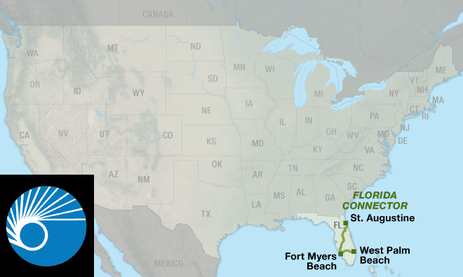
|
|---|---|
| 1. St. Augustine, FL to West Palm Beach, FL (507.8 mi.) | Detail
Florida Connector Section 1 Detail Image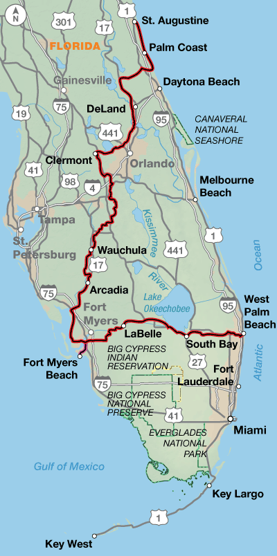
|
See Florida from coast to coast to coast.
The Florida Connector creates the opportunity for two loop routes in Florida that are ideal for cycling December through March. It joins the Atlantic Coast Route, Section 7, in St. Augustine and West Palm Beach creating the first loop option. A second loop encompassing West Palm Beach, Key West, and Fort Myers Beach via a ferry is also possible.
Florida has an extensive though sometimes confusing network of bicycling facilities ranging from 2-foot bike lanes or shoulders to separated bike paths and sidewalks. Some stretches are better suited to sidewalk cycling due to moderate to heavy traffic; in other areas sidewalks will be pedestrian use only. The approach to often nearly invisible short bridges are usually marked with "frogs", "buttons", "turtles", "slugs" or rumble strips.
Heading south from St. Augustine mostly on SR A1A, the route alternates between urban and suburban conditions along the coast until it swings west at Bulow Creek State Park. You will wind your way through many lakes and sinkholes. Sometimes you'll see huge trucks filled with oranges, and you may even see a live (or dead) armadillo along the side of the road. In the Orlando area, you'll experience the mind-boggling traffic and myriad services associated with Disney World. The route is only five miles away from the main entrance. Continuing south, it's more swamps, farms, and orange groves.
From DeLeon Springs to Clermont the route strings together several bike paths, including the Spring-to-Spring Trail, Seminole Wekiva Trail, and West Orange Trail.
Traveling east from Fort Myers, you once again leave the tourist corridor behind and have a chance to encounter the more residential and rural aspects of Florida. Lehigh Acres, a planned community, is ample evidence of the development to come. Between LaBelle and Clewiston your companions will mostly be birds and reptiles. Services through this swampland are few and far between. Alligators tend to fear humans but give them a wide berth anyway. The route skirts the southern banks of Lake Okeechobee on a path built by the Corps of Engineers. The route into West Palm Beach returns you to more urban riding conditions and the connection with the Atlantic Coast Route near the airport.
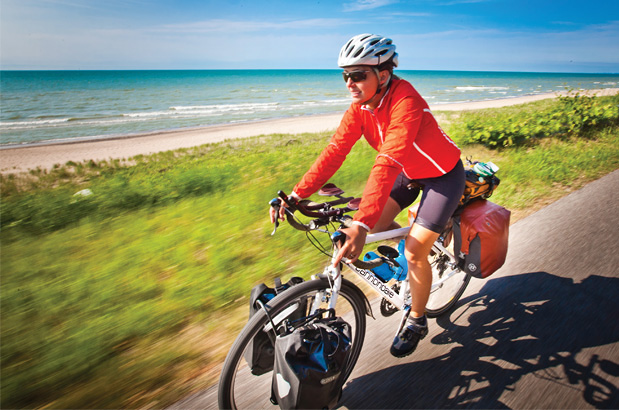
Photo by Adam Coppola
Generally the terrain is either rolling or flat.
| Florida Connector - Main Route | ||||
|---|---|---|---|---|
| Section | Distance | Elevation | Total Climb | Avg. Climb/mile |
| Total | 507.8 miles | Minimum: 0 ft. Maximum: 220 ft. |
6,265 ft. south bound 6,330 ft. north bound |
12 ft. per mi. south bound 12 ft. per mi. north bound |
| Florida Connector Alternates | ||||
|---|---|---|---|---|
| Name | Section | Distance | Total Climb | Avg. Climb/mi |
| Ferry Spur | 1 | 12.2 miles | 60 ft. south bound 75 ft. north bound |
5 ft. per mi. south bound 6 ft. per mi. north bound |
Services are plentiful in the urban areas but can be scarce in residential/suburban and rural areas. This route may be ridden all year round. Caution: the hurricane season is from June 1 to November 30.
Some campgrounds will charge a cyclist traveling alone less if they have hiker/biker sites, but often they will charge the price of a regular tent site, and that can easily be $10-$20+/night. If you're friendly and ask around, you can often get yourself invited to camp in a yard. Many small town city parks are free to camp in.
Route Highlights
- St. Augustine
- Fort Matanzas National Monument
- Washington Oaks Gardens State Park
- De Leon Springs State Park
- Blue Spring State Park
- Walt Disney World
- Bok Tower Gardens
- Lake Okeechobee
More Route Resources
- U.S. Bicycle Route System
- U. S. Bicycle Route 1
- How to Travel on Amtrak with your Bicycle
- Flagler Beach to Marineland Trail
- Daytona Bike Week (motorcycle event)
- Spring-to-Spring Trail
- Cross Seminole Trail
- Seminole Wekiva Trail
- West Orange Trail
- Key West Express ferry
- Lake Okeechobee Scenic Trail
- Connect and share photos with other riders on Instagram: #acaFlConn
RIDING CONDITIONS
U.S. Bicycle Route (USBR) 1 has been designated in Florida. Portions of our route run concurrent with it. For more information and maps see advcy.link/flusbr.
Riding south from St. Augustine, SR A1A along the coast is a two-lane beach access road that carries a considerable amount of weekend traffic but little commercial truck traffic.
The Flagler Beach to Marineland Trail, advcy.link/flaglermarinelandtrl, is used by the route for 19.7 miles and offers a break from riding on the highway.
For 10 days in late February into early March, Daytona Beach and Volusia County are hosts to an annual gathering billed as "the world's largest motorcycle event." Traffic increases and lodging of all types becomes difficult to find during this period. Advanced reservations are highly recommended. See officialbikeweek.com for exact dates.
Heading west across Bulow Creek State Park the route follows country roads through several small towns toward DeLand. Occasionally, the Highbridge Rd. bridge across the Halifax River is closed due to heavy rains and you will need to detour 9.5 mi. south into Ormond Beach via John Anderson Dr. You can reconnect with the route by following Beach Rd./Old Dixie Hwy. 10 mi. northward.
Past DeLand, the route links together several suburban bike trails, including the Spring-to-Spring Trail, advcy.link/springtospringtrl, Cross Seminole Trail, advcy.link/crossseminoletrl, Seminole Wekiva Trail, advcy.link/seminolewekivatrl, and West Orange Trail, advcy.link/worangetrl.
Disney World is located off route between Clermont and Loughman. Traffic increases due to the route passing within 5 miles of the main entrance. U.S. 192 is a 4-lane road with high volumes of cars and RV’s. Many campgrounds and motels along U.S. 192 offer shuttle bus service into Disney World, which is most likely the easiest way to reach this entertaining extravaganza.
The route then begins a zigzagging journey through ranches, farmland, and grassland on various county roads before finally reaching the tea-colored Peace River near Wauchula to begin a (slightly) downhill ride to the coast.
U.S. 17 has bike lanes from Arcadia to Nocatee, and good shoulders and/or sidewalks the rest of the way to Punta Gorda. Expect higher levels of urban traffic in Punta Gorda.
The route again becomes rural, traversing large, developing subdivisions north of Cape Coral. Bike paths take you through much of the canal town of Cape Coral. The route crosses the Caloosahatchee River on the 2-mi. long Midpoint Bridge. The bridge has wide shoulders in both directions.
You’ll be riding in urban traffic when you reach the historic town of Fort Myers. Sidewalk riding is allowed, and often preferred, in the urban perimeters of Ft. Myers and West Palm Beach; sidewalks frequently do double duty as bike paths. Pay attention to signage as sidewalk riding is not always legal.
A 12.2-mi. spur leads from Fort Myers to the Key West Express Ferry in Fort Myers Beach. The ferry service from Ft. Myers Beach to Key West departs every morning at 8:00 a.m. arriving into Key West around 11:30 a.m. It is advisable to have reservations. Space is limited on the ferries, so be sure to let them know in advance that you have a bike. The official policy of the ferry is no trailers are allowed and panniers must be removed. It is advised that you have bungies to secure your bike. Call Sea Key West Express for information about cost and schedules at 239-463-5733 or check their website: keywestexpress.net. Do this well in advance of your departure. All luggage is screened so you need to ask what items (like pocket knives, fuel canisters, tent stakes, etc.) are prohibited when you make your reservation.
To skip the urban areas around Punta Gorda and Ft. Myers, take SR 31 from SR 70 (1.5 mi. E. of Arcadia) to N. River Rd./CR 78 (10 mi. W. of Alva). This rural 34-mi. stretch of highway has few services, but does have shoulders the entire way.
Southern Florida is often swampy and ringed with low-lying mangrove jungles. Watch for small alligators in the more rural areas between LaBelle and Clewiston. From Moore Haven to South Bay you will be riding on the Lake Okeechobee Scenic Trail (L.O.S.T.), advcy.link/lost, atop the Herbert Hoover Dike along the southern shore of one of the largest freshwater lakes in the contiguous United States. There are no restrooms or services on the dike, and there are limited access points to enter or exit the trail. This area can provide good wildlife viewing, particularly in fall and winter when wintering waterfowl are abundant.
The route uses 1.9 miles of U.S. 98/441 before the bike path appears on the north side of the highway. Traffic is fast and heavy and the shoulders are narrow. Ride with caution.
The end of the route in West Palm Beach connects you to the Atlantic Coast Bicycle Route. Two loops can be made by using this map with the Atlantic Coast Section 7 map: a smaller southern loop using the Key West Express Ferry, and a larger triangle-shaped loop in the central part of the state.
All known Amtrak stations are listed on this map but not all stations provide bicycle service. Check if bicycle service is provided at both the starting and ending stations on your trip using the spreadsheet and other trip planning resources at advcy.link/amtrak.
CLIMATE
Climate is probably Florida’s greatest natural resource, making both its thriving tourist and agricultural trades possible. Summers throughout the state are long, warm, and humid; winters are mild because of the southern latitude and the relatively warm adjacent ocean waters.
Frequent rainfall and gentle breezes on the coasts make the heat much easier to take. Hurricane season is typically from June through November.
Updated: Aug 11, 2022-
GPX Data |
Overview
Florida Connector Overview Image

- 1. St. Augustine, FL to West Palm Beach, FL (507.8 mi.)
-
Detail
| Map Updates and Corrections
Florida Connector Section 1 Detail Image

See Florida from coast to coast to coast.
The Florida Connector creates the opportunity for two loop routes in Florida that are ideal for cycling December through March. It joins the Atlantic Coast Route, Section 7, in St. Augustine and West Palm Beach creating the first loop option. A second loop encompassing West Palm Beach, Key West, and Fort Myers Beach via a ferry is also possible.
Florida has an extensive though sometimes confusing network of bicycling facilities ranging from 2-foot bike lanes or shoulders to separated bike paths and sidewalks. Some stretches are better suited to sidewalk cycling due to moderate to heavy traffic; in other areas sidewalks will be pedestrian use only. The approach to often nearly invisible short bridges are usually marked with "frogs", "buttons", "turtles", "slugs" or rumble strips.
Heading south from St. Augustine mostly on SR A1A, the route alternates between urban and suburban conditions along the coast until it swings west at Bulow Creek State Park. You will wind your way through many lakes and sinkholes. Sometimes you'll see huge trucks filled with oranges, and you may even see a live (or dead) armadillo along the side of the road. In the Orlando area, you'll experience the mind-boggling traffic and myriad services associated with Disney World. The route is only five miles away from the main entrance. Continuing south, it's more swamps, farms, and orange groves.
From DeLeon Springs to Clermont the route strings together several bike paths, including the Spring-to-Spring Trail, Seminole Wekiva Trail, and West Orange Trail.
Traveling east from Fort Myers, you once again leave the tourist corridor behind and have a chance to encounter the more residential and rural aspects of Florida. Lehigh Acres, a planned community, is ample evidence of the development to come. Between LaBelle and Clewiston your companions will mostly be birds and reptiles. Services through this swampland are few and far between. Alligators tend to fear humans but give them a wide berth anyway. The route skirts the southern banks of Lake Okeechobee on a path built by the Corps of Engineers. The route into West Palm Beach returns you to more urban riding conditions and the connection with the Atlantic Coast Route near the airport.
Photo by Adam Coppola
RIDING CONDITIONS
U.S. Bicycle Route (USBR) 1 has been designated in Florida. Portions of our route run concurrent with it. For more information and maps see advcy.link/flusbr.
Riding south from St. Augustine, SR A1A along the coast is a two-lane beach access road that carries a considerable amount of weekend traffic but little commercial truck traffic.
The Flagler Beach to Marineland Trail, advcy.link/flaglermarinelandtrl, is used by the route for 19.7 miles and offers a break from riding on the highway.
For 10 days in late February into early March, Daytona Beach and Volusia County are hosts to an annual gathering billed as "the world's largest motorcycle event." Traffic increases and lodging of all types becomes difficult to find during this period. Advanced reservations are highly recommended. See officialbikeweek.com for exact dates.
Heading west across Bulow Creek State Park the route follows country roads through several small towns toward DeLand. Occasionally, the Highbridge Rd. bridge across the Halifax River is closed due to heavy rains and you will need to detour 9.5 mi. south into Ormond Beach via John Anderson Dr. You can reconnect with the route by following Beach Rd./Old Dixie Hwy. 10 mi. northward.
Past DeLand, the route links together several suburban bike trails, including the Spring-to-Spring Trail, advcy.link/springtospringtrl, Cross Seminole Trail, advcy.link/crossseminoletrl, Seminole Wekiva Trail, advcy.link/seminolewekivatrl, and West Orange Trail, advcy.link/worangetrl.
Disney World is located off route between Clermont and Loughman. Traffic increases due to the route passing within 5 miles of the main entrance. U.S. 192 is a 4-lane road with high volumes of cars and RV’s. Many campgrounds and motels along U.S. 192 offer shuttle bus service into Disney World, which is most likely the easiest way to reach this entertaining extravaganza.
The route then begins a zigzagging journey through ranches, farmland, and grassland on various county roads before finally reaching the tea-colored Peace River near Wauchula to begin a (slightly) downhill ride to the coast.
U.S. 17 has bike lanes from Arcadia to Nocatee, and good shoulders and/or sidewalks the rest of the way to Punta Gorda. Expect higher levels of urban traffic in Punta Gorda.
The route again becomes rural, traversing large, developing subdivisions north of Cape Coral. Bike paths take you through much of the canal town of Cape Coral. The route crosses the Caloosahatchee River on the 2-mi. long Midpoint Bridge. The bridge has wide shoulders in both directions.
You’ll be riding in urban traffic when you reach the historic town of Fort Myers. Sidewalk riding is allowed, and often preferred, in the urban perimeters of Ft. Myers and West Palm Beach; sidewalks frequently do double duty as bike paths. Pay attention to signage as sidewalk riding is not always legal.
A 12.2-mi. spur leads from Fort Myers to the Key West Express Ferry in Fort Myers Beach. The ferry service from Ft. Myers Beach to Key West departs every morning at 8:00 a.m. arriving into Key West around 11:30 a.m. It is advisable to have reservations. Space is limited on the ferries, so be sure to let them know in advance that you have a bike. The official policy of the ferry is no trailers are allowed and panniers must be removed. It is advised that you have bungies to secure your bike. Call Sea Key West Express for information about cost and schedules at 239-463-5733 or check their website: keywestexpress.net. Do this well in advance of your departure. All luggage is screened so you need to ask what items (like pocket knives, fuel canisters, tent stakes, etc.) are prohibited when you make your reservation.
To skip the urban areas around Punta Gorda and Ft. Myers, take SR 31 from SR 70 (1.5 mi. E. of Arcadia) to N. River Rd./CR 78 (10 mi. W. of Alva). This rural 34-mi. stretch of highway has few services, but does have shoulders the entire way.
Southern Florida is often swampy and ringed with low-lying mangrove jungles. Watch for small alligators in the more rural areas between LaBelle and Clewiston. From Moore Haven to South Bay you will be riding on the Lake Okeechobee Scenic Trail (L.O.S.T.), advcy.link/lost, atop the Herbert Hoover Dike along the southern shore of one of the largest freshwater lakes in the contiguous United States. There are no restrooms or services on the dike, and there are limited access points to enter or exit the trail. This area can provide good wildlife viewing, particularly in fall and winter when wintering waterfowl are abundant.
The route uses 1.9 miles of U.S. 98/441 before the bike path appears on the north side of the highway. Traffic is fast and heavy and the shoulders are narrow. Ride with caution.
The end of the route in West Palm Beach connects you to the Atlantic Coast Bicycle Route. Two loops can be made by using this map with the Atlantic Coast Section 7 map: a smaller southern loop using the Key West Express Ferry, and a larger triangle-shaped loop in the central part of the state.
All known Amtrak stations are listed on this map but not all stations provide bicycle service. Check if bicycle service is provided at both the starting and ending stations on your trip using the spreadsheet and other trip planning resources at advcy.link/amtrak.
CLIMATE
Climate is probably Florida’s greatest natural resource, making both its thriving tourist and agricultural trades possible. Summers throughout the state are long, warm, and humid; winters are mild because of the southern latitude and the relatively warm adjacent ocean waters.
Frequent rainfall and gentle breezes on the coasts make the heat much easier to take. Hurricane season is typically from June through November.
Updated: Aug 11, 2022Generally the terrain is either rolling or flat.
Florida Connector
- service waypoints
- 253
- minimum elevation
- 0 ft.
- maximum elevation
- 220 ft.
- south bound total climbing
- 6,265 ft.
- north bound total climbing
- 6,330 ft.
- south bound climb per mile
- 12 ft. per mi.
- north bound climb per mile
- 12 ft. per mi.
Florida Connector Alternates
- name
- Ferry Spur
- distance
- 12.2 miles
- south bound total climbing
- 60 ft.
- north bound total climbing
- 75 ft.
- south bound climb per mile
- 5 ft. per mi.
- north bound climb per mile
- 6 ft. per mi.
Services are plentiful in the urban areas but can be scarce in residential/suburban and rural areas. This route may be ridden all year round. Caution: the hurricane season is from June 1 to November 30.
Some campgrounds will charge a cyclist traveling alone less if they have hiker/biker sites, but often they will charge the price of a regular tent site, and that can easily be $10-$20+/night. If you're friendly and ask around, you can often get yourself invited to camp in a yard. Many small town city parks are free to camp in.
- St. Augustine
- Fort Matanzas National Monument
- Washington Oaks Gardens State Park
- De Leon Springs State Park
- Blue Spring State Park
- Walt Disney World
- Bok Tower Gardens
- Lake Okeechobee
More Route Resources
- U.S. Bicycle Route System
- U. S. Bicycle Route 1
- How to Travel on Amtrak with your Bicycle
- Flagler Beach to Marineland Trail
- Daytona Bike Week (motorcycle event)
- Spring-to-Spring Trail
- Cross Seminole Trail
- Seminole Wekiva Trail
- West Orange Trail
- Key West Express ferry
- Lake Okeechobee Scenic Trail
- Connect and share photos with other riders on Instagram: #acaFlConn
