Western Express Route Section 3 GPX Data
Please note, GPX Data is not refundable! Please examine the sample data on the device of your choice before purchasing GPX data packages. More information about GPX Data files can be found here.
After your GPX purchase, you can get GPX updates for free by re-downloading them from your My Adventure Cycling account.
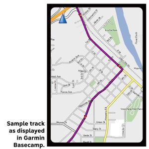
GPX Data products consist of track and service waypoint files in gpx (GPS Exchange Format) file format to be used on a GPS device, smartphone, or tablet. These products are suggested as a companion product to the printed Adventure Cycling Route maps and feature the same services listed on the physical maps. More information about GPX Data for Devices can be found here.
Section 3 of the Western Express Route begins in Cedar City, Utah, and ends in Dolores, Colorado. You'll see some of the most spectacular scenery in America along paved roads, and the route provides access to a large number of national parks, monuments and state parks. Take some extra time to explore and do some hiking and biking into the off-route parks. This section is considered very difficult due not only to terrain (grades from 6% to 14% in Utah), but also due to lack of water, temperature extremes, and long mileages without services. In most cases there are no homes or ranches between services. Carrying a water purifier is stongly advised for water access at Lake Powell and for miscellaneous reservoirs, creeks and lakes at primitive campsites. Utah is extremely dry and most of the route has only rocks for shade.
More information about this route is available here.
GPX Data Resources
- GPX Data Agreement
- Support Pages for Digital Route Data products
- Map Updates and Corrections (Addenda) - Always be sure to check for map updates and corrections before leaving on your trip.
- Temporary Road Closure Information
- Frequently Asked Questions
* These products are delivered in compressed zip files. Instructions on extracting the data are located here.
**NOTE: Occasionally, the GPX data you purchase will be newer than the paper map currently being sold. They may still be used together. See the Tracks and Service Points FAQs for more information.**
Reviews
There are currently no reviews for this product, be the first!


