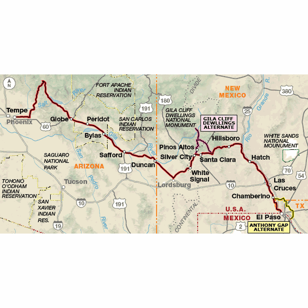
Expect urban cycling conditions with traffic from Tempe to the turn northward toward Usery Pass. After turning onto SR 87, there is a five-mile section of narrow road with no shoulder. Full service towns include Tonto Basin, Roosevelt, Globe, and Safford. Services on U.S. 70 are minimal in eastern Arizona. In Duncan, replenish your stock of food and water. Services are very limited until you reach Silver City. A two-mile detour to Lordsburg is an option for full services. Once you reach Silver City, New Mexico, you have a choice. The main route goes through rolling terrain; enroute you’ll pass the Santa Rita Open Pit Copper Mine. In comparison, the Gila Cliff Dwellings Alternate is 69 miles longer. The alternate goes through historic Pinos Altos and climbs and descends through thick pine forests before reaching the Gila River drainage. This very scenic road is narrow and winding and caution is urged, especially on the descents. After leaving the Gila Cliff Dwellings National Monument, you ride through forests and meadows, and begin another gradual ascent to the Continental Divide. SR 152 is winding and steep with intermittent shoulders over Emory Pass, the highest point on the Southern Tier. Heading south the route parallels the Rio Grande and I-25. SR 28 winds through small towns, farm fields, and pecan groves into El Paso. Click on enlargement for detail.
Good move to reroute the Southern Tier from Mesa to Globe. From BikeCentennial to Adventure Cycling Association my wife and I have used these maps for numerous loaded tours, including the Section 2 of the Southern Tier. Over the years these bicycling maps have steadily improved. Unfortunately the states have not responded to or kept up with the need for safer passage for cyclists. I applaud ACA for its efforts to find safe alternatives and publish them as ACA maps. They are easy to follow and read, and provide almost every conceivable bit of information that a cyclist needs to complete his or her bicycle ride on any particular ACA bike route. Well worth the money to have a relatively carefree bicycle trip.
Response to above review from our Cartography department
Rating:
Reviewed By:
Cartography on 6/8/15
Unfortunately, there aren't a lot of options in that area. We are however, aware of this situation and are sending a researcher out to investigate alternatives for the next map update. Thank you for your feedback.
The big dangerous catch to this section.
Rating:
Reviewed By:
Alex on 6/5/15
I've been riding ACA routes since 2011 from OR to NY to FL to TX and now this year back to OR when we rode this route. The stretch of Hwy 60 between Globe and Superior was by far the most I've ever feared for my life. Steep ascents and descents, little to no shoulder, rumble strips, and then guardrails. On top of that traffic is very heavy with recreational and industrial vehicles, there are three active mines on the road. The cherry on top is a long tunnel on the west end where a local told us two cyclist have been hit in the past five years (thankfully not killed). The map says heavy weekday traffic but it should say DO NOT attempt on a weekday. If your on a trike or have a wide trailer, forget about it. We ended up hitching a ride and I'd advise the same. The rest of this section was great but avoid this part if at all possible.
Southern Tier Part 2
Rating:
Reviewed By:
Kevin John Eddy on 10/5/11
nice looking map, but the proof comes in the pudding???
Let me ride the complete route first, then we shall see how good they are!
Kevin


 based on 4 reviews.

