San Francisco, CA - Santa Barbara, CA (383.1 miles)
Product Code
BD-1622
Brand
Adventure Cycling Association
Price
$10.99
These GPX Data products cannot be used with the Bicycle Route Navigator App! Unless you plan to use a standalone GPS device, we highly recommend purchasing route sections WITHIN the Bicycle Route Navigator app.
Please note, GPX Data is not refundable! Please examine the sample data on the device of your choice before purchasing GPX data packages. More information about GPX Data files can be found here.
After your GPX purchase, you can get GPX updates for free by re-downloading them from your My Adventure Cycling account.
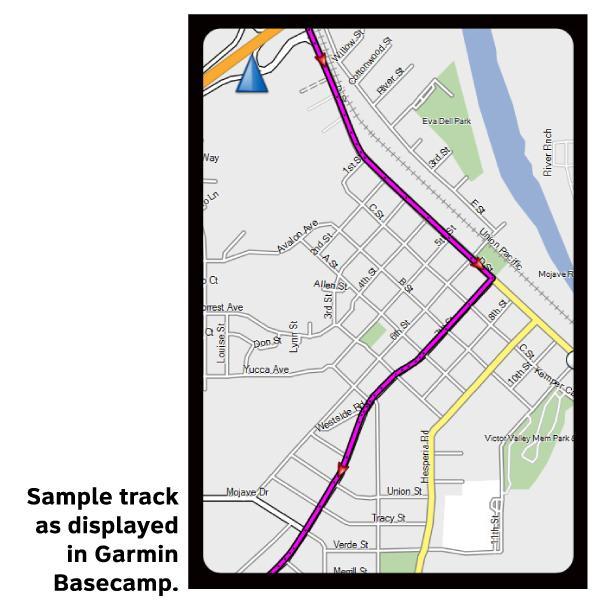
GPX Data products consist of track and service waypoint files in gpx (GPS Exchange Format) file format to be used on a GPS device, smartphone, or tablet. These products are suggested as a companion product to the printed Adventure Cycling Route maps and feature the same services listed on the physical maps. More information about GPX Data for Devices can be found here.
Because the heavy motorized traffic tends to be even heavier in the summer, we recommend that you ride this route in the spring or autumn. May and September/October are the best months for riding. From the Golden Gate Bridge, the route heads directly to the coast via city streets. After rejoining SR 1, you'll encounter heavy traffic but here SR 1 has shoulders in most places. From Carmel Heights to San Simeon there are few services. This is a beautiful but demanding road with minimal shoulders traversing open grasslands and timbered slopes above the ocean. State and national campgrounds provide sites overlooking the beach. They are quiet in the off season but extremely busy in the summer. You'll encounter five major climbs along the border of the Los Padres National Forest; one of these takes you to almost 1,000 feet above the Pacific Ocean. The route flattens south of Harmony. From Morro Bay to Pismo Beach you'll leave SR 1 for local, county, and state roads with intermittent shoulders. At Oceano you'll head inland, then join US 101 and ride back to the coast. West of Goleta you'll leave US 101 and travel along business arterials to enter Santa Barbara.
More information about this route is available here.
* These products are delivered in compressed zip files. Instructions on extracting the data are located here.
**NOTE: Occasionally, the GPX data you purchase will be newer than the paper map currently being sold. They may still be used together. See the Tracks and Service Points FAQsfor more information.**
I have plan to cycle the Pacific Route one of these days that's why I purchased one section of the route (digital). I just wanted to see how it looks. It seems to me that information is very good, particularly about lodging, so I know, more or less, where to spend a night. It also contains info on bike shops, point of interests, and even libraries. All in all, good products.
Good value, easy to download
Rating:
Reviewed By:
Peter Roberts on 1/4/17
I bought sections 4 and 5 of the Pacific Coast Bike route in the digital format. They were good value and easy to download and open. The updates system is easy to use and useful for recent changes.