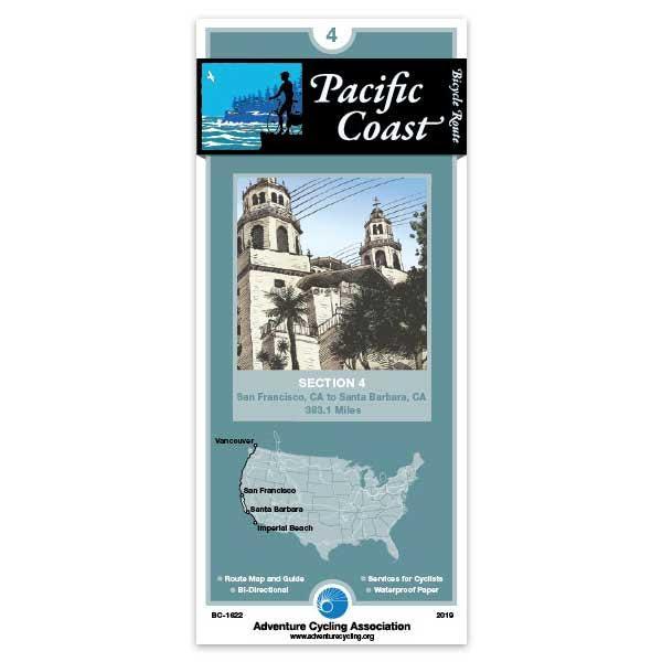
San Francisco, CA - Santa Barbara, CA (383.1 miles)
Product Code
BC-1622
Brand
Adventure Cycling Association
Price
$16.75
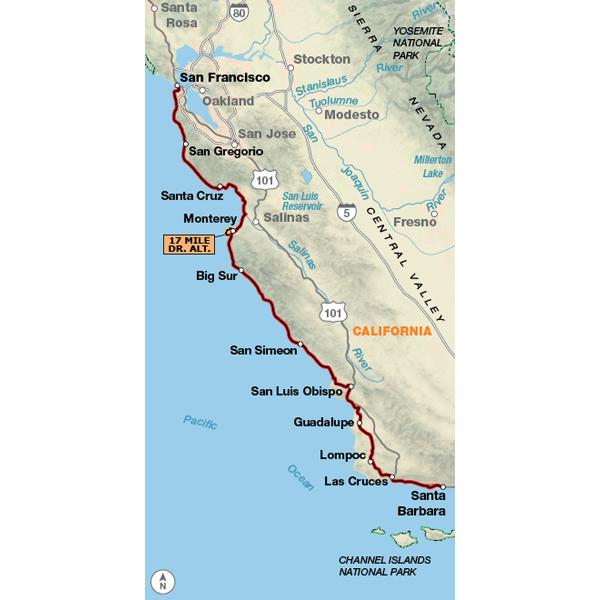
Because the heavy motorized traffic tends to be even heavier in the summer, we reccommend that you ride this route in the spring or autumn. May and September/October are the best months for riding. From the Golden Gate Bridge, the route heads directly to the coast via city streets. After rejoining SR 1, you'll encounter heavy traffic but here SR 1 has shoulders in most places. From Carmel Heights to San Simeon there are few services. This is a beautiful but demanding road with minimal shoulders traversing open grasslands and timbered slopes above the ocean. State and national campgrounds provide sites overlooking the beach. They are quiet in the off season but extremely busy in the summer. You'll encounter five major climbs along the border of the Los Padres National Forest; one of these takes you to almost 1,000 feet above the Pacific Ocean. The route flattens south of Harmony. From Morro Bay to Pismo Beach you'll leave SR 1 for local, county, and state roads with intermittent shoulders. At Oceano you'll head inland, then join US 101 and ride back to the coast. West of Goleta you'll leave US 101 and travel along business arterials to enter Santa Barbara.
Rode Sunset Beach (south of Santa Cruz) to Pfeiffer State Park (just south of Big Sur) and back. I adored this ride and found the map essential to keeping me off highway 1 where it was unsafe. I would never have found the agricultural backroads on my own. Very much recommend stopping at the artichoke stand just off the bike path north of Monterey!
I also found that the campgrounds listed first on the map amenities section were independently the ones most recommended by locals - Monterey Veteran's Memorial Park and Pfeiffer each had great hike/bike sections with showers nearby.
Get you there
Rating:
Reviewed By:
Luke M on 12/6/16
I did a 1.5 day trip starting at the Golden Gate Bridge, and ending just shy of Half Moon Bay. The map was a good reference for getting there, and its references like for the Montara Hostel were useful.
There were two main difficulties/annoyances I had with the tiny part of the map my route was on. First I had troubles with correlating the map with the world around me in the Golden Gate Recreation area. While I was faffing about trying to figure out if I needed to turn around at one point a nice gentleman pointed me the direction I needed to go. Even then I thought I was off route, and only now looking at Strava I find out I was on route... Chalk it up to me being dumb if you like, it only would have taken an ounce of local knowledge for the map to be sufficient in that case.
The other thing is that in Pacifica there is a bike path that gets you off of the 1 which is not marked on the map. I think that small part of the trip had some of the best views. Going SB you would have to be blind to miss it.
Would I use again/buy again? Yes but I would approach the route with a little more skepticism than I did this time.
The book was better
Rating:
Reviewed By:
Steve o on 10/5/16
I purchased the book for the pacific coast trail and like it so much I bought the maps as well. I found the map print to be too small and wasn't the best resource. I ended up tearing the directions out of the book for each day's ride and following that instead. And then for times we needed food or a bike shop, we used google in our iphones. By the time I got to the second map of the trail, I didn't even use it at all - overall, good quality, good information, but too small and wasn't really useful during the ride.
Map is easy to use.
Rating:
Reviewed By:
Harry on 9/13/16
Rode San Francisco to Santa Monica, the route map was indispensable..
Got us through to Santa Barbara perfectly...recommended for traveling with bike extremely handy!
Good job
Rating:
Reviewed By:
Klaus Paffhausen on 10/31/12
I bought the pacific coast route and trans america 15 years ago and they were absolutely top notch, but the upgrade is even better... especially the new waterproofed quality. Next year, i plan a trip from Alaska down to Yosemite where i live. Soon I'll order great parks north and Lewis and Clark routes. Your maps are the best, thank you Klaus
It Works!
Rating:
Reviewed By:
David Woods on 7/10/12
I recently did a 6 day ride from Big Sur, CA, to Redondo Beach, CA, on the Pacific Coast Route. I was leery of paying $15 for a map so I purchased only the San Francisco to Santa Barbara segment prior to departure. I felt I could find my way through Santa Barbara and the Ventura/Oxnard area which I managed to do but when I ran off the end of the ACA map I kicked myself for not buying the Santa Barbara to San Diego map as well.
At first glance the format of the map did not appear to me like it would be a useful tool but in practice it worked very well! It presents the route in concise segments that can easily be displayed in a standard map holder. In contrast, I used a standard road map for the Ventura/Oxnard area and it was very cumbersome and not possible to fold it in such a way as to show the route well or to fit the map holder.
The campground, lodging, dining/food information and elevation profile on the ACA map were also very helpful.
In summary I will not go on another tour without ACA maps of the entire route.
Adventure Cycling maps
Rating:
Reviewed By:
Steve Kurek on 1/9/12
The summer of 2010 I used your maps to ride the TransAm Trail
from Yorktown, VA to Florence, OR. In my opinion there is no better way to bike tour than using your excellent maps. You can navigate this entire country turn by turn without any other help.
An added bonus is that they are waterproof.
US 101 North of Santa Barbara
Rating:
Reviewed By:
A customer from Los Angeles on 11/8/11
This is a good map with much information. However, what is missing is how to travel north through the Gaviota tunnel on US 101. We have tried and needed to stop each time because of the tunnel.
map review
Rating:
Reviewed By:
Dylan Haley on 10/4/11
hello there.
yes, your map was excellent.
I do have 2 comments. Some of the camp sites where not great... perhaps the good sites should have stars? Or "campsites" with concrete floors and ONLY rv's should be noted as such?
Also, After i started the trip I saw that this route was not suggested in the month of August, and I saw why when i got to the shoulder-less section of Big Sur. If you ever re-print the map you could add in HUGE letters to make sure to avoid the route during the Pebble Beach Concours d'Elegance and Monterey Auto Week August 13-19. I guess this is an annual event and it's just my luck that I was in the Big Sur area during that week! I had to turn around and call it quits early due to the Ferrari's and the like passing me at 100 mph!
Not your fault, but that would be my suggestion.
Adversity is part of bike touring, I still had a great trip. Thanks for doing what you do!.
Dylan (dyl-doggy)
Used for Monterey to Carpenteria
Rating:
Reviewed By:
A customer from The Sea Ranch, CA on 9/7/11
At times I would have liked more detail. For Santa Barbara County I did use their free bike route map - very helpful in getting from Santa Barbara to Carpinteria.
Pacific Coast Route Section 4
Rating:
Reviewed By:
Patrick Lynch on 3/4/11
1st: There are well marked bike trails through Santa Barabara. While there is some hill climbing, they seemed preferrable to the route you outline. 2nd, and more important: The notes are way, way too vague. I remember especially the note just outside of Monterey where the northbound biker exit route 1 is supposed to pick up a bike path. That path is neither marked nor obvious. I ended up on the 17-mile drive which was nice, but I was nervous because I was off route and the light was failing. There were other instances that I didn't note, but it seems to me that the notes/text is, in general, much too spare and unnecesarily so.
Pacific coast route
Rating:
Reviewed By:
A customer from Menlo Park, CA on 4/12/10
Maps are fantastic - really well done. Thanks so much.
2 small
Rating:
Reviewed By:
A customer from Felton California on 2/16/10
A bunch of tiny little maps of route pieces printed on a large map is almost useless. I expected better from this organization .
Pac Coast Route 4
Rating:
Reviewed By:
Adrian De Kroon on 12/3/09
Highly recommended! Couldn't have done the trip without it - it's a must!
Map, Pacific Coast Route Section 4
Rating:
Reviewed By:
A customer from Carson City, Nevada on 11/5/09
The maps are good. Also, in this segment the book "Bicycling the Pacific Coast" is also good. The book is more about camping and offers little in the way of info on motels, hostels, etc. The map has better info on food and motels, etc. The map lags behind the book in elevation profiles as the book has distance and elevation all in one place, very easy to use and see. The map has elevations for the entire route in one place, the maps elsewhere. I know this is a small issue. Overall, I would not want to travel without the maps.
Pacific Coast Route Section 4, Review
Rating:
Reviewed By:
Steve Albano on 9/25/09
Overall, this map was very helpful in my recent tour from Monterey CA to Santa Barbara CA. Each section of the map was pretty acurate, and I found the elevation profile to be very helpful. The mapped route did it's best to keep us out of heavy traffic areas, but in one area, I would have opted for a more direct route. In Goleta, the route had us go on an extended tour of UCSB via a bike path. Again, this was to keep us out of traffic, but there is a well marked route call "Cross Town", that is safe, and much more direct. Just my opinion. Otherwise this is a very useful tool! Thanks!!
Pacific Coast Route Section 4
Rating:
Reviewed By:
Karl Littau on 7/1/09
Very good although I would recommend staying on Hollister Ave. through the first part of Santa Barbara (going south) until Modoc Rd. The bike paths in Santa Barbara add significant distance and are confusing. I got lost twice on them. Traffic on Hollister isn't that bad. Otherwise it was an excellent experience made possible by good maps.
pacific coast route section 4
Rating:
Reviewed By:
A customer from Hercules, CA on 7/1/09
I have used this map for 4 or 5years as i ride down the coast from the San Francisco Bay area almost every summer. Last year i met two Canadian riders heading north from just above the Malibu CA area. They were young and adventurous and had no maps or idea of what they were getting into. I offered them both the southern section i carry and the section 4 map. They took the Santa Barbara to SF section and so i needed to replace it. I don't feel comfortable without a map and these are great maps.
Easy to use map!
Rating:
Reviewed By:
A customer from Santa Monica, CA USA on 6/11/09
The map was great. It fit right into my handlebar bag. The route took us off the main highway where possible to avoid traffic and to enjoy the scenery. I really enjoyed the half moon bay bike path.
The campsite listings and bike shop listings were also very useful.
The route does pass up the 17 mile drive in the Carmel area. It would be nice if the map included a possible detour to include part of the 17 mile drive.
CA coast map
Rating:
Reviewed By:
A customer from Vancouver, BC Canada on 12/25/06
This map is full of excellent information, particularly the HILLS! haha Thank you for providing a great source of information for our trip down the coast.