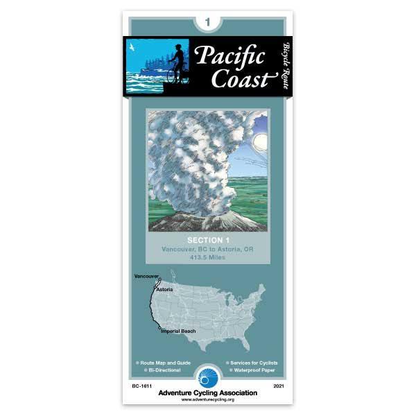
Vancouver is a relatively easy city to bicycle through. After crossing the border into Washington, you'll be riding on narrow two-lane roads on level terrain. There are no shoulders, and traffic is light. Bellingham is a larger town with moderate traffic and some congested intersections. Separated bike paths are used along the route wherever possible. Whidbey Island has occasional rolling to hilly terrain. There are several narrow two-lane sections and congested areas near the island's towns; traffic is generally light away from SR 20. South of Port Townsend, the route is rolling to hilly on mostly low-trafficked rural roads through farms and forests. West of Longview, in southern Washington, SR 4 carries moderate recreational traffic in the summer. After crossing the Columbia River via ferry, in Oregon, you'll ride west on US 30, which carries moderate traffic and has shoulders most of the way into Astoria, the beginning and end points for the TransAmerica Bicycle Trail and the Lewis & Clark Bicycle Trail.
Excellent except for a little hiccup in Centralia, when the route mistakenly led us to a service road and then said “Route Finished”. We backtracked, followed the real map and were backoncourse.
Never Lost
Rating:
Reviewed By:
John Rockwood on 5/13/19
The only times I've been lost on tours is when I didn't have my Adventure Cycling maps.
Pacific Coast 1, 2 and 3
Rating:
Reviewed By:
Mathias Houwen on 10/17/18
When rating 4 means "good", I agree.
I cycled in september 2018 from Vancouver/BC over Vancouver Island, then to Washington, Oregon and California to San Francisco. 2.200 km.
Pacific Coast 1: I was surprised that the map did not include the route from Port Angeles to the Pacific along the west coast.
Pacific Coast 1, 2 and 3: the descriptions of the route are very precise and easy to follow. But in a very narrow corridor: as soon as I wanted to take a road to the left or the right, there was not much on the map any more.
However, together with the book "Bicycling the pacific coast" and "Google maps" (sometimes, when internet available!) I managed perfectly to find my way.
pacific coast and nth route
Rating:
Reviewed By:
paul edwards new zealand on 5/17/18
very good as allways my third big ride coming up arrive van. jun 3 to do nth route other rides cont. div.5000km and 20000km around usa.ACA maps are the way to go
So far so good!
Rating:
Reviewed By:
Lindy on 11/30/16
I haven't started my trip yet but so far the map has been very helpful in my planning. Good details! I like the listings for all the camping grounds, emergency numbers etc. A great idea.
Pacific Coast Route 1 Section
Rating:
Reviewed By:
Ron Cohen on 7/23/16
Overall, this was very helpful once I got used to the symbols and layout. It's helpful to use a smart phone or GPS along with this, to check that the important information is current and to get back on course if taking a detour or wrong turn. I like the fact that the route has been researched for the optimum in safety/scenery, not just the fastest route. I cycled from Seattle to San Francisco, but initially only bought the Section 1 and 2 maps, which end in Crescent City, CA. I liked these maps enough to go out of my way to find the Section 3 map in Brandon, OR, fearing that I could miss the better or safer options for the rest of the trip.
Maps are not accurate
Rating:
Reviewed By:
Anonymous on 8/4/11
I purchased the map #1 for Washington coast. Navigating past Bremerton was difficult and so we resorted to a regular map. Some of the roads described in the caption did not exist.
Got us to the church on time
Rating:
Reviewed By:
A customer from Norfolk, va on 8/3/11
A good guide for getting out of Vancouver. We got off the train, got on the bike and made Bellingham, WA by dinnertime. Detoured down 101along the Hood canal rejoining the route in Shelton, WA, then veered off again at Castle Rock and picked up the STP route into Portland for our daughter's wedding. Googled for hotels alng the way. A great trip overall!
Pacific Coast Route Section 1
Rating:
Reviewed By:
Louis Trottier on 3/7/11
Excellent map! compact, resist to rain, have telephone numbers and addresses for tourist offices, emergencies (just in case) and accomodations (ex. : lodging). I intend to follow the routes indicated in each of the 13 minimaps. It looks like it has been made from multiple experiences over the years. Do not regret my purchase.
Very helpful tool
Rating:
Reviewed By:
Steven Gerber on 10/13/10
Overall the map was very good. My only complaint was that if you miss a turn or get off course there is nothing on the map to help you figure out where you are so you can get back on track. next time i'll compensate by carrying additional maps and a GPS
review of PC Route 1 and 2
Rating:
Reviewed By:
A customer from Colorado Springs, CO on 9/13/10
The maps were very helpful and a good size. The only problem we had was consistently finding and staying on the designated route without being able to see other roads in the area that intersected the route. A larger perspective would offer the rider greater assistance but would necessitate a larger map. Several times we got on a wrong road and were unable to figure out where we went wrong without the visual help of a larger map.
Pacific Coast route #1
Rating:
Reviewed By:
Stephens Parker on 4/17/10
All AC maps that I have used have been accurate and helpful. I have not ridden this route yet, but the map appears to look fine.


 based on 12 reviews.
