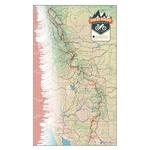
Great Divide + Canada Map Set GPX Data

Map Details
Jasper, AB - Antelope Wells, NM (3,086.4 miles)
Product Code
BD-2010
Brand
Adventure Cycling Association
Price
$69.00
Current File Version
Jun 6, 2023

These GPX Data products cannot be used with the Bicycle Route Navigator App! Unless you plan to use a standalone GPS device, we highly recommend purchasing route sections WITHIN the Bicycle Route Navigator app.

Please note, GPX Data is not refundable! Please examine the sample data on the device of your choice before purchasing GPX data packages. More information about GPX Data files can be found here

After your GPX purchase, you can get GPX updates for free by re-downloading them from your My Adventure Cycling account.

GPX Data products consist of track and service waypoint files in gpx (GPS Exchange Format) file format to be used on a GPS device, smartphone, or tablet. These products are suggested as a companion product to the printed Adventure Cycling Route maps and feature the same services listed on the physical maps. More information about GPX Data for Devices can be found here.

The world's longest mountain bike route, this route traces the Continental Divide from Canada to Mexico on dirt and gravel roads, some pavement and some singletrack. 

For more information on this route or to print out the most up to date addenda for these maps please click on these links: Great Divide, Great Divide Canada

GPX Data Resources

* These products are delivered in compressed zip files. Instructions on extracting the data are located here.

**NOTE: Occasionally, the GPX data you purchase will be newer than the paper map currently being sold. They may still be used together. See the Tracks and Service Points FAQs for more information.**


Reviews

Average rating: based on 1 reviews.

New maps are wonderful

Rating:

Reviewed By: Linda Gryczan on 8/11/18

It is worth investing in the new maps for the many, many updates. Having just finished riding the GDMBR from Banff to Helena, I found the new maps easier to follow. The new icons mark significant points with a circled letter, made it much easier to locate myself. North & South directions are great. Often I was able to conserve my GPS battery and just go with the cue sheets. The only concern I have is the amount of single track in Canada. Personally I loved it (at least until my bear encounter). It was wonderful riding for those of us who are experienced single track riders traveling light. As I headed south of Sparwood on the Elk Valley Trail, I found most others taking the highway. I think most riders would be best served with a choice of single track and back roads. Those who aren't up for so many kilometers of trails, could take a gravel alternative instead of heading for the highway.

Add Product Review