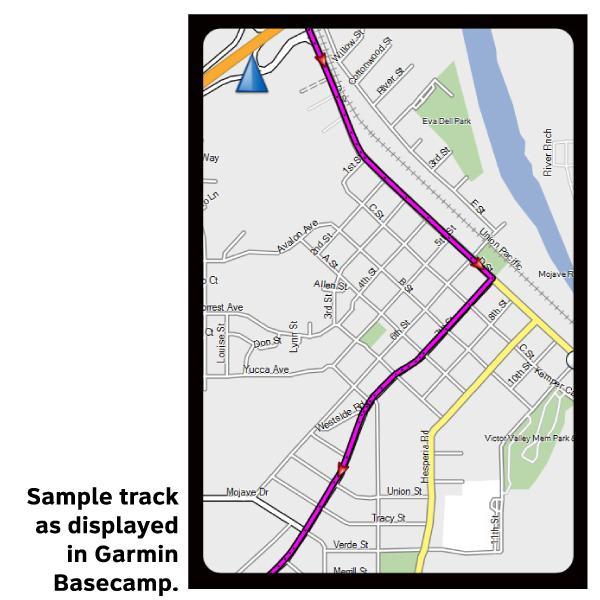
Atlantic Coast Section 2 GPX Data


Please note, GPX Data is not refundable! Please examine the sample data on the device of your choice before purchasing GPX data packages. More information about GPX Data files can be found here.
After your GPX purchase, you can get GPX updates for free by re-downloading them from your My Adventure Cycling account.
GPX Data products consist of track and service waypoint files in gpx (GPS Exchange Format) file format to be used on a GPS device, smartphone, or tablet. These products are suggested as a companion product to the printed Adventure Cycling Route maps and feature the same services listed on the physical maps. More information about GPX Data for Devices can be found here.
Western Connecticut is rural and quite hilly. As you enter New York, the roads are generally good and signing is adequate. Expect a moderate amount of traffic which increases as you approach towns. You'll continue to encounter hills until reaching Hyde Park, in the Hudson River Valley. You'll follow this rolling valley south to busy Poughkeepsie, and cross the Hudson River on the walkway over the Hudson pedestrian bridge. The route follows river valleys and crosses the Shawnagunk Mountains to Port Jervis at New York/New Jersey border. Here, you'll begin to parallel the course of the Delaware River. Roads south of Delaware Water Gap through the remote Delaware Valley are narrow and poorly paved. You'll cross the Delaware River for the final time in Lambertville, New Jersey, which is near Trenton. The route continues west from Lambertville into Conshohocken. The New York Spur traverses rural countryside until it reaches the suburbs of eastern New Jersey where you'll encounter urban riding conditions. Click on enlargement for detail.
More information about this route is available here.
GPX Data Resources
- GPX Data Agreement
- Support Pages for Digital Route Data products
- Map Updates and Corrections (Addenda) - Always be sure to check for map updates and corrections before leaving on your trip.
- Temporary Road Closure Information
- Frequently Asked Questions
* These products are delivered in compressed zip files. Instructions on extracting the data are located here.
**NOTE: Occasionally, the GPX data you purchase will be newer than the paper map currently being sold. They may still be used together. See the Tracks and Service Points FAQs for more information.**
You may also like:
Reviews
There are currently no reviews for this product, be the first!