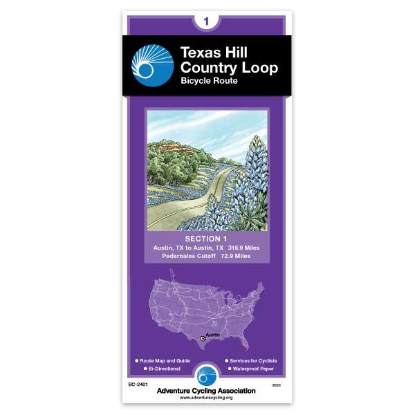
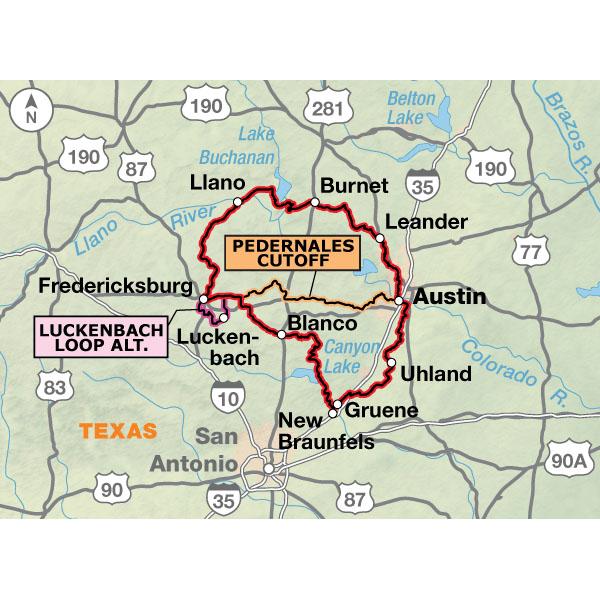
Bluebonnets and other wildflowers in the spring, historic sites, local music, friendly towns, rivers and state parks all can be experienced when you ride this route. Summer cyclists can go "toobing" on several rivers in the area. The loop begins and ends in Austin, and includes cutoff routing in case your tour is only for a long weekend. Using the cutoff shortens the route to 213 miles. If you stay in Fredericksburg for several days, the 30.5-mile Luckenbach Loop Alternate can be done as a day ride.
I rode solo in December 2020 and found the paper map a valuable planning resource and good backup in case of technology failure. I was off route a lot intentionally and would refer to the map or app to create my route for the next day. Given it was easy to go 15+ miles and not see a single commercial establishment I was able to plan my water, snacks, and breaks better.
Great info on a great map
Rating:
Reviewed By:
Hawk Mendenhall on 5/25/20
Having spent the last 18 years riding around the Texas Hill Country it was fun to finally have a map that made sense as opposed to having to rely on my memory and my many cycling friends hastily given directions. Really a well done map!
Great Route, OK Map
Rating:
Reviewed By:
Chouwalker on 4/24/19
I rode this route in April of 2019. The route is fantastic, especially at this time of year. The weather was warm but not hot and there are wildflowers everywhere. The route took me through some very beautiful country. The roads were uncrowded and I never had to deal with cars in any way that felt uncomfortable. I did the route clockwise in 6 days. I parked at Austin Airport to start and ended my days in New Braunfels, Blanco, Fredricksburg, Llano, and Bertram (in that order). It was a miraculous ride in that i had a tail wind every single day as I rode in a giant circle (thank god I didn't go the other direction!!!). There are lots of hills, but no big climbs. Most days I was doing on the order of 55 mi and 1700 ft of elevation gain.
I had both the Bicycle Route Navigator smartphone app with the route and the paper map of the route. I bought the map for the smartphone app first, but found it unusable for trip planning (hard to get the big picture on a smartphone screen). I bought the paper map for planning the trip and it was OK for that. Ironically, I bought the paper map because I hated looking at the route one small piece at at time. It turns out the paper map is also broken up into many small segments (about 30 mi each) and fails to provide a good big-picture view (except for one small overview map which lacks sufficient detail). What i really wanted was a single large map with decent detail showing the entire route. That does not seem to exist. Once on the tour, I used the Bicycle Route Navigator app exclusively to follow the route. This worked very well and I did not need the paper map on the trip. For finding services in a given location (e.g. restaurant, hotel, bike shop), Google on my smartphone was way better than either the paper map or the app.
Texas Hill Country Loop
Rating:
Reviewed By:
James S. on 10/19/17
I just finished this tour with my 12-year old son. The maps are excellent. Easy to follow. Adventure Cycling has devised an ingenious method of conveying a wealth of information on a small piece of paper. I don't fault Adventure Cycling, but a decent percentage of this route is on roads with very small or non-existent shoulders. The traffic may be light, but being passed by trucks at 70 mph takes some getting used to. With that said, Texas drivers are the most courteous I have encountered, (although I suppose it only takes one bad driver to kill you.) The Texas countryside is beautiful, and I liked every town we hit. If I had one recommendation, it would be to take the Luckenback Loop. This was the best riding of the tour, and Luckenback had a nice food truck. One other recommendation - we rode clockwise from Austin. If I had it to do over, I'd take the local train to Leander, and then ride this tour counterclockwise. This would cut out some of the suburban riding around Austin - not terrible, but the worst part of the trip.
Fun Ride
Rating:
Reviewed By:
Richard Cutler on 7/3/17
We took this ride with 5 adults and 8 kids from Burnett to Blanco over Spring Break. North of Fredricksburg there were tons of wildflowers. Took a side trip to spend the night at Enchanted Rock...totally worth it. Ended up doing a rest day in Fredricksburg to see the WWII Pacific museum which was a lot of fun. Roads do not have a lot of shoulder, but the drivers were mostly friendly. One driver convinced us to take an alternate route which was a mistake...stick with the published route!
Just bought the Texas Hill Country Map
Rating:
Reviewed By:
Chuck on 2/27/17
I just bought the Texas Hill Country map as a "bucket list" item. I live in Nebraska and recently got back into bicycling after some absence. I have ridden several multi- days tours in Nebraska. Iowa, upstate New York, and Vermont over the years, but have been away from touring for some time. So I'm trying to get my legs back. Recently I purchased a Brompton folding bike that I researched for some time. At first, it looked like a toy, but after months of watching and listening to many YouTube videos and reading two books on the Brompton, I decided to make the purchase. I'm flirting with the idea of a week tour in Texas after or before attending the Garner State Park 60s Style Reunion in mid May. So, I bought the Hill Country map with the notion of giving the Brompton a chance to prove itself in Texas. It really depends if the Nebraska winter will contour to corporate with my bike training. Sure do miss my home state (born in Corpus Christi) and try to return for an annual "Texas fix" every year. Enjoy reading these posting "y'all"! Happy Trails!
You Had Better Like Hills
Rating:
Reviewed By:
John on 5/29/16
Since I live in Austin, I was very excited to see this new route listed. I bought my map online about an hour after they first went on sale. Next day I put in for vacation and took off on the new Hill Country Loop as soon as possible. I also plan on writing a more complete journal on the crazyguy site, complete with pictures and more specifics.
Overall, the route is pretty good. There are some sections that are absolutely fantastic, but there are other sections that only serve to connect together the good parts. I would have shifted the whole route to the west a bit more and skipped the area around Austin altogether. I guess the planners wanted to include a mix of good scenery and cultural destinations.
A few bits of advice: Never pass up the opportunity to refill your water bottles. I took four bottles and could have used more. On the roads with heavy traffic, use bright lights – even in day time. Wear bright colors. Do not ride in Austin, Cedar Park, or Leander during rush hour. In fact, avoid riding in those places at all if you can arrange it. The traffic in Leander/Cedar Park is heavy, fast moving, and unfriendly. Avoid the River Road between Gruene and Sattler during summer weekends. This is the DWI highway full of idiots during ‘toobing’ season. Do not try and camp in Fischer. If you do, say Hi to the Sherriff Department officers for me.
Almost every square inch of Texas is privately owned. Your planning for this trip needs to revolve around where you are going to stop for the night. On other tours I have done some guerilla camping in West Texas and farther west in the Hill Country, but there are not many spots along this route to do that.
Reduce the weight you are carrying by every possible ounce. Cut the handle off your toothbrush etc. Some of the hills you will climb are very steep, although they don’t last for long. You will always be going up or going down on this route. There are almost no flat sections.
The best times to ride this will be in the spring wildflower season or in the fall. March and October are usually good times to ride in Central Texas. The temperatures are not too high, but you might still get hit with a cold front so be prepared for sudden temperature drops. I went in May 2016 after a particularly rainy spring and the wildflowers were still in bloom and were amazing.
If you can afford the time, plan on spending some rest days in Fredericksburg and Austin. Keep your daily mileage down and take time to enjoy what there is to see along the route.