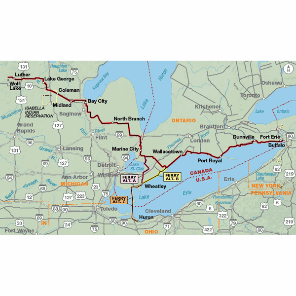
The Lake Erie Connector is intended primarily as a shortcut that saves about 250 miles between the North Lakes Route near Wolf Lake, Michigan, and the Northern Tier Route at Fort Erie, Ontario. It also connects to the Northern Tier Route across the western end of Lake Erie at Sandusky, Ohio, and enables a variety of loop rides in the lower Great Lakes region. The route traverses the farms and fields of central Michigan, and then follows the northern shoreline of Lake Erie in Canada.
Traveled this route summer 2018. Took a detour, dropping down from Luther, on the Kings Rd, to the rail trail into Reed City. The rail trail before Reed City is gravel, and it was not really ridable (too many 4-wheelers had churned it up), but the road into Reed (hwy 10) was decent. From Reed City to Farwell was excellent, and we were so glad to have done that detour. From Farwell to Midland, excellent rail trail. We did another detour from Brockway over to Avoca, so we could take the entire Wadhams-Avoca rail trail. We are so glad we did, because the trail was wonderful (the nice packed fines that roll so smooth). The routing through Ontario was clear, though the ferry at Marine City was out, and we used the ferry in Algonac, and went through Wapole Island to get back on route. Stopped over night on Pelee Island, camping, which we highly recommend. All the information about ferries and lodging and all was fantastic. This was a great connector map. Wish we could have ridden the north side of Lake Erie, but we had family to visit in Ohio!
Maps
Rating:
Reviewed By:
Carl Heltne on 1/11/19
We used parts of the Northern Tier route last year. They were very useful. In addition to the routes, the narrative and information regarding lodging helped significantly. We are using the Lake Erie Connector this coming summer.
We are most appreciative of all the work and recommed this resource to many other riders
A friend and I rode
Rating:
Reviewed By:
Agus on 11/17/13
A friend and I road-tripped from Chicago to Niagara Falls in January 2002. It was a great experience. We actually traveled both routes and made a circle around Lake Erie. We went to Niagara Falls using the southern route through Ohio/Pennsylvania/New York, and then returned via Ontario/Detroit. If speed and efficiency are a priority, I would recommend the Detroit to Canada route. However, my friend and I found it fascinating to stop and look at Lake Erie in Ohio, Pennsylvania, and New York as we traveled and made the trip an experience in itself. There's a state road in Pennsylvania we followed for a bit (rather than the interstate) that added an hour or so to the trip but was worth it. It loosely follows the lake and offers views of some beautiful vineyards.Border crossings in New York and Michigan were smooth and fast most likely due to the fact that we crossed in the evening both times. We had a bit of difficulty locating the crossing in New York, but that probably was due to inexperience and darkness. References : Personal experience Made the trip five years ago. Was this answer helpful? http://ykdlrs.com [url=http://fgjipmhesoo.com]fgjipmhesoo[/url] [link=http://ccxewgmml.com]ccxewgmml[/link]
Lake Erie Connector Map
Rating:
Reviewed By:
Patrick Clark on 12/25/06
I have done 4 sections of the Northern Tier using Adventure Cycling Maps. They are great and the GPS Waypoints make them outstanding. I do appreciate the amount of research that goes into them. They are well worth the cost, especially adding the GPS Waypoints to the equation.