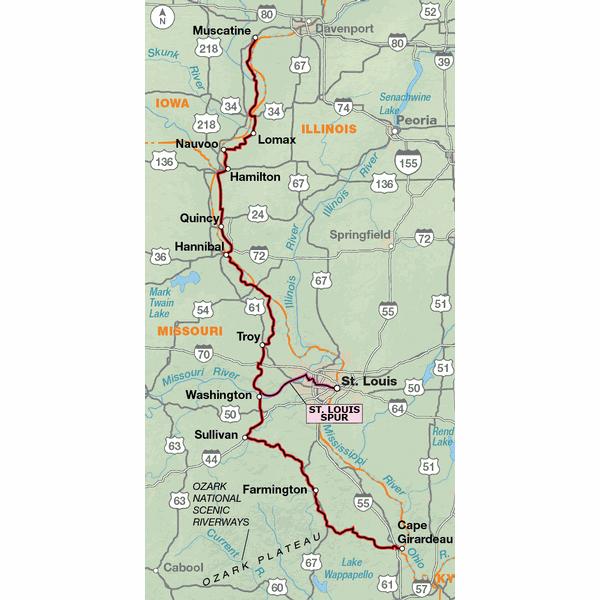
From Muscatine, Iowa, southward to Hannibal, Missouri, the route closely follows the flood plain of the Mississippi River. The riverside roads in Iowa and Illinois are rural narrow farm-to-market roads, connecting small farming communities along the river. The Mississippi bridge crossing into Missouri at Hannibal brings you into Mark Twain territory. You'll encounter some steep roller coaster hills before reaching the Missouri River. Riding on 3.9 miles of the Katy Trail between Marthasville and Dutzow, travel will be slower due to its crushed limestone surface, though more pleasant than the highly trafficked SR 47/94. South of Washington, you’ll be entering the Ozark Mountain range. Roads are narrow, winding, and steep, with short sight distances. After Cherokee Pass, the route leaves the mountains and moves onto the alluvial plains of southeastern Missouri to Cape Girardeau. The map also shows a 56-mile spur route into St. Louis which includes 30.5 mi. of the Katy Trail. After crossing the Missouri River you’ll switch to urban cycling as the route heads into the heart of the city. With care, riders who are accustomed to larger cities will have no problem with this spur to downtown St. Louis and the famous Gateway Arch. Click on enlargement for detail.
We rode from St. Louis to just short of Muscatine. The route was very nice, ranging from flat on the Illinois side to fantastically hilly south of Hannibal. (A previous reviewer commented that the Hannibal-Louisiana road was closed in 2011; it is open now (2012), and very hilly.
There are a few mistakes on the route guide that are not fixed in the addendum yet, but they are relatively insignificant. The most significant one was the claim that you can camp in the park in Louisiana, MO. You can't. The police said that we could camp south of town in what seemed like a toxic waste dump (complete with smelly effluent flowing into the river), but we opted to stay in a nice motel, instead.
Challenging and Fun
Rating:
Reviewed By:
Brent McLaughlin on 8/31/11
In 6 days, we road over half of this route from Nauvoo, IL to St. Louis, Missouri and stayed in Bed and Breakfasts along the way. The route truly has it all. The terrain is quite varied from flat riverfront roads along the Mississippi River, to gently rolling Missouri farm land to steep up and down "mountain" like roads along the river bluff to a section of the Katy Trail. Some of the towns along the way were quite interesting (i.e. Nauvoo, Hannibal, St. Louis). There was a significant road closure this summer (2011) which we were informed by locals that it may become permanent due to a massive landslide. It is between Hannibal and Louisiana, Missouri. The detour was 7 miles on a gravel road. Everywhere along this route, we found people to be extremely friendly and helpful. It seemed like they didn't often see folks touring on bicycles.