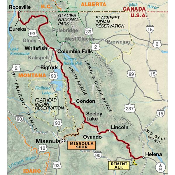
This section of the Great Divide Mountain Bike Route is entirely within Montana. The route begins at the border and quickly enters forested backcountry. It skirts the western border of Glacier National Park along North Fork Flathead River. The route goes through towns every 4-5 days for restocking supplies. You'll either be going over passes or riding through valleys en route to the next climb, and it's considered the most challenging portion of the entire route. You'll go through historic mining regions lying between Seeley Lake and Helena, Montana. Fascinating historic sites beckon in the state’s capital of Helena, so plan to lay over at least a day to catch them.
New to this edition of GDMBR maps is a spur route from Seeley Lake to Adventure Cycling’s hometown of Missoula. At just a hair over 65 miles, this is a challenging route through a maze of steep terrain on a mix of surfaces including overgrown old logging roads and singletrack trail.
I'm absolutely enjoying these 5 maps, the time, dedication and effort that was invested in creating the maps is evident. My adventure is coming soon and I'm confidently relaying in the information contain in them. The work of the ACA promoting and inspiring a bicycle life style and adventure is powerful and contagious. Thank you!
great divide maps
Rating:
Reviewed By:
someone planning this route on 2/27/19
looks amazing with all the details iv never had on a map as i v bin quiet punk-biking recycling about so lets see!
and so ,of never really have used a map like this i can't tell but will post my opinion about after using
cheers enjoy!!
Nice upgrade
Rating:
Reviewed By:
William Smith on 8/11/18
This is my 3rd version of this map, and it has more landscape detail than ever. I used it to ride the GDR from Bigfork to Seeley Lake, and the Missoula Spur in July 2018. I would note that having an accurate odometer or GPS would be advisable. Some of the route doesn't get much traffic, and it would help to know you have gone far enough to reach the next turn. Water comments very useful. Highly recommend the hiker-biker camp sites at Placid Lake S.P.
Great map!
Rating:
Reviewed By:
Awesomesauce on 2/9/18
The only bad thing is I bought the map in January. And it won't stop snowing
Bears and dust
Rating:
Reviewed By:
Peter Hewitt on 8/9/17
Excellent map, used on the ACA's Great Divide, Canada II outing of July 2017. The two modifications I would make are 1. a warning that the Smith-Dorrien Spray Rd can be highly unpleasant with deep gravel, and an 80 kph speed limit that can leave cyclists hidden in the wake of dust, which extends over 10 meters high. Thus, aim for patience and low-traffic hours. This road was the site of a clavicular fracture and thus removal of 20% of our original group, may he Recover In Peace ( one of 5 people) 2. A phone number could? be included that would give riders a report of recent bear activity/sightings in the area? Bears get an awful lot of attention, fear. Getting the latest "forecast" and a chance to talk to informed local personnel might greatly diminish such anxiety.
Lastly, I see, under General Information, a note about discouraging attempting to ride this route solo. There is no indication as to why this route has such a warning whereas other routes do not. Is the danger from wildlife, from single-track/rough riding, lack of emergency services, unusual weather patterns, gnarly native hermits? Or is this in fact a general warning that goes on all ACA maps?
Great Divide Mountain Bike Route,Section 1
Rating:
Reviewed By:
A customer from Helena,Montana on 8/10/09
The map is excellent.I like the fact it is more durable
than your average map so it will last.The route directions were accurate for the most part and the history of the area provided was a nice touch.I think the map would be easier to use in a loose leaf format
were you could take sections out individualy.It would probably cost more and be cumbersome though.