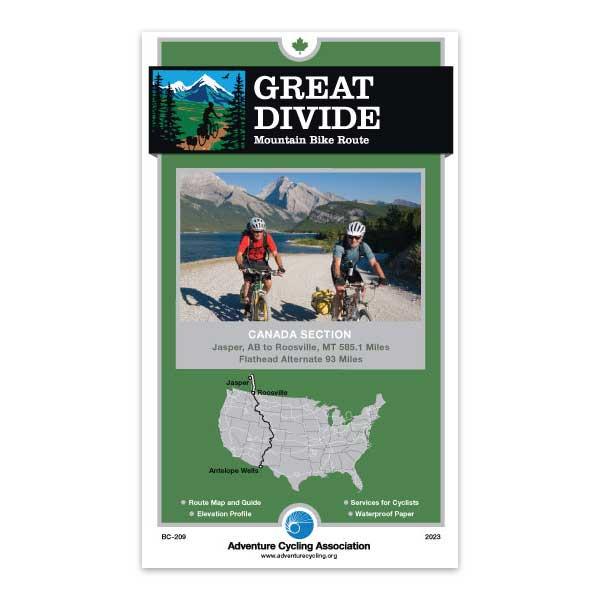
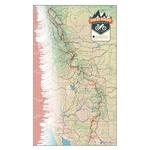
This route extends the Great Divide Mountain Bike Route into Canada along both the spine and foothills of the Rocky Mountains. Beginning in Jasper, the route counterintuitively runs north to Hinton before heading southward along the lonesome Forestry Trunk Rd. to Bow River near Canmore. The paved Legacy Trail brings riders into Banff and through spectacular scenery to Peter Lougheed Provincial Park. The route uses Elk Pass to cross the Continental Divide (known as the Great Divide in Canada). The main route follows portions of the Elk Valley Trail from Round Prairie to Elko with a spin through Fernie along the way. South of Fernie, you can choose to continue on the main route or ride across the "Serengeti of North America" through miles and miles of unbridled wilderness on the Flathead Alternate. The endpoint is Roosville, which is the beginning of the U.S. stretch of the Great Divide Mountian Bike Route.
Amazing detail. As an avid cycle adventure guy, I appreciate a detailed map. My Great Divide maps are just that. I could spend hours pouring over and memorizing all the info in these maps. Like I said, 'amazing'.
Information We Need
Rating:
Reviewed By:
Dwight Hirsch on 1/9/20
The map should be a great help in planning a trip from Banff to Whitefish. I am also sure it will prove to be useful along with GPS navigating the route.
GDMBR Map
Rating:
Reviewed By:
Adrian Pearce on 7/11/19
I was pleased to receive my order so quickly in the mail. Having ordered a map before (The Underground Railway), I knew I could expect a highly detailed and helpful map. Keep up the good work!
Bears and dust
Rating:
Reviewed By:
Peter Hewitt on 8/10/17
Excellent map, used on the ACA's Great Divide, Canada II outing of July 2017. The two modifications I would make are 1. a warning that the Smith-Dorrien Spray Rd can be highly unpleasant with deep gravel, and an 80 kph speed limit that can leave cyclists hidden in the wake of dust, which extends over 10 meters high. Thus, aim for patience and low-traffic hours. This road was the site of a clavicular fracture and thus removal of 20% of our original group, may he Recover In Peace ( one of 5 people) 2. A phone number could? be included that would give riders a report of recent bear activity/sightings in the area? Bears get an awful lot of attention, fear. Getting the latest "forecast" and a chance to talk to informed local personnel might greatly diminish such anxiety. Lastly, I see, under General Information, a note about discouraging attempting to ride this route solo. There is no indication as to why this route has such a warning whereas other routes do not. Is the danger from wildlife, from single-track/rough riding, lack of emergency services, unusual weather patterns, gnarly native hermits? Or is this in fact a general warning that goes on all ACA maps?
It's not a map, it's a route
Rating:
Reviewed By:
Paul on 6/13/15
You shouldn't give it a lower rating because you didn't research it well enough and had wrong expectations. It is clearly advertised as a route not a map listing multiple options. We used it in 2011 and it was fantastic. Really didn't need it for Banff to Sparwood but I am map guy and having one is always a good reason to take a break or kill time in your tent. Well done AC.
Great Divide Route Maps
Rating:
Reviewed By:
Richard Goulah on 9/11/12
Excellent layout and quality
ok
Rating:
Reviewed By:
A customer from Amsteram, the Netherlands on 2/4/12
it's not a map as of more a route. I ordered this map thinking it would show more of the region instead of just one route so I could make some educated choices when Im cycling in that area. It is great and very detailed and I'm sure it will be quite useful. But not what I expected.
Great Divide Canada Route
Rating:
Reviewed By:
A customer from New Westminster, BC, Canada on 10/5/10
Unfortunately the map did not arrive prior to our departure on the trip - no fault of yours - Canada Post! However with the info we gleaned from your web site and local topographical maps we were able to follow most of the route.
On arriving home and seeing the wonderful detail of your map, we were delighted with the map and only wished that we had been able to use it. Will definitely purchase your maps again for more of the same trail. Thanks
Great Success
Rating:
Reviewed By:
Josh Jack on 6/5/09
I was already impressed with the Adventure Cycling TransAm routes, but despite their accuracy, I was still skeptical on how well they would route a dirt trail.
Turns out, the Great Divide route is just as easy to follow as any of their road routes, and has all the bike specific information you come to expect. I purchased the route from Banff all the way to the US/Mexico border, and they are accurate all the way through. The addendas are great piece of mind that you're getting the most up to date information, and the customer service at the main office is outstanding. If there's something I can't figure out, I can always give them a call and get some advice.