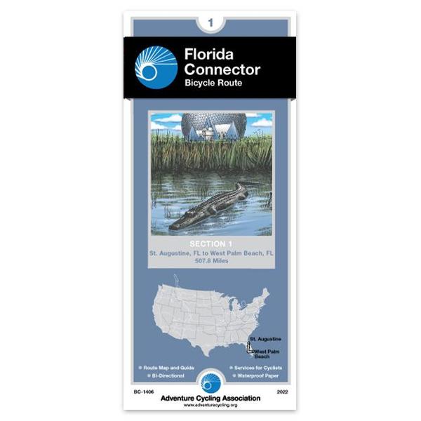
St. Augustine, FL - West Palm Beach, FL (507.8 miles)
Product Code
BC-1406
Brand
Adventure Cycling Association
Price
$16.75
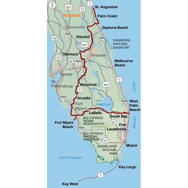
Heading south from St. Augustine mostly on SR A1A, the route alternates between urban and suburban conditions along the coast until it swings west at Bulow Creek State Park. You will wind your way through many lakes and sinkholes. Sometimes you'll see huge trucks filled with oranges, and you may even see a live (or dead) armadillo along the side of the road. In the Orlando area, you'll experience the mind-boggling traffic and myriad services associated with Disney World. The route is only five miles away from the main entrance. Many campgrounds and motels offer shuttle service into Disney World, which would be the best way to reach this fun spot. Continuing south, it's more swamps, farms, and orange groves.
From DeLeon Springs to Clermont the route strings together several bike paths, including the Spring-to-Spring Trail, Seminole Wekiva Trail, and West Orange Trail.
Traveling east from Fort Myers, you once again leave the tourist corridor behind and have a chance to encounter the more residential and rural aspects of Florida. Lehigh Acres, a planned community, is ample evidence of the development to come. Between LaBelle and Clewiston your companions will mostly be birds and reptiles. Services through this swampland are few and far between. Alligators tend to fear humans but give them a wide berth anyway. The route skirts the southern banks of Lake Okeechobee on a path built by the Corps of Engineers. The route into West Palm Beach returns you to more urban riding conditions and the connection with the Atlantic Coast Route near the airport.
Ft. Myers, a transportation center and access point to the famous Everglades, serves as a pivot point of the route with its ferry services.
I notice that all but one of the previous reviews were by people who did not actually travel the route. We tried to follow this route from around Fort Lauderdale to Fort Myers. We found 2 problems: parts of the route were along very busy highways,and the other problem was that the actual safe (and less ugly) parts of the route were closed for construction (and had been for some time). We spent 5 years traveling around different parts of the world on our bikes, and our opinion is that if want to cycle, don't do it in Florida.
Flordia Connector Map Review
Rating:
Reviewed By:
A customer from Mooresville, North Carolina on 11/1/12
I haven't actually traveled the Florida connector as of yet. However, I have been using the Adventure Cycling Connector map (along with other resources) to plan a trip in January 2013. For planning purposes, I find the map to be very helpful. However, to provide a more accurate review of the map, I should return after my trip and submit another review.
Florida Connector
Rating:
Reviewed By:
Robert Colvin on 4/7/11
As always a good map. I'm planning my trip, so have not used it, but have good reference points and so am researching my ride.
Florida Connector
Rating:
Reviewed By:
A customer from Southampton UK on 1/12/10
Have used the ACA maps for a couple of trips and well worth getting, this one answered my question about getting from Celebration to the east coast. Looks an interesting route. I use the ACA maps as a guide for planning - don't always stick to them but they are a good start and great help for getting through/round big cities.
Florida Connector and Atlantic Coast Section 7 Maps Review
Rating:
Reviewed By:
A customer from Windsor, Ontario, Canada on 12/25/06
We used the Adventure Cycling Association's Florida Connector map and started in Port Charlotte. We traveled to Fort Myers Beach, then headed east across the state to Fort Lauderdale where we continued with the ACA Atlantic Coast Section 7 map and made our way to Key West. We stayed there for a couple of days then took the ferry service back to Fort Myers Beach. From there we retraced one leg of our route back to our car in Port Charlotte. This was an interesting loop to travel.
The Adventure Cycling Association maps were very helpful. The only snags that we had were on the I 75 ramps at Weston ( see http://www.crazyguyonabike.com/doc/page/?o=RrzKj&page_id=143685&v=3h for a full description of our problems) and the heavy traffic and dangerous, narrow road conditions on Card Sound Road outside of Florida City ( see http://www.crazyguyonabike.com/doc/page/?o=RrzKj&page_id=144023&v=3B ).
Thanks for the helpful maps. If the above mentioned problems were fixed in future publications of these maps, the entire route for bicycle tourists doing the Florida Loop would be more enjoyable and much safer.


 based on 5 reviews.
